The high temperature range is about to expand north Tropical disturbance still brewing at sea
Since July, the southern region of my country has experienced two large-scale high-temperature heat waves. The number of high-temperature days in Jiangxi, Zhejiang, Fujian and other places has exceeded 25 days, and many sites have broken through historical extremes. It is expected that starting from August, the high temperature range in the south will expand to the north, and Henan, Shandong, Hebei, Shaanxi and other places will also join the ranks of high temperature. This year’s No. 5 typhoon “Sanda” has entered my country’s Yellow Sea and continues to move northward. The Central Meteorological Observatory continues to issue a blue typhoon warning. In addition, there are currently 1-2 tropical disturbance activities in the ocean east of Taiwan, and typhoons may be generated in the future, which will have an impact on the southeastern sea area of my country.
On July 31, there were still high temperature weather in Jiangnan and South China, but the intensity range was weaker than before. The highest temperature in parts of northwestern Inner Mongolia, eastern southern Xinjiang Basin and Turpan, southern Hunan, central and southern Jiangxi, central and southern Zhejiang, most of Fujian, eastern Sichuan, western Chongqing, northeastern Guangxi, and central and northern Guangdong is 37-39 °C. , Xinjiang Turpan Basin can reach more than 40 ℃ locally.
From August 1, the high temperature range will expand northward, and high temperature weather will also occur in southern North China, southern Shaanxi, Huanghuai, Jianghan, and western Jianghuai.
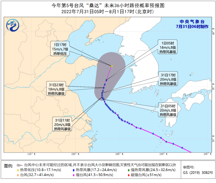
The Central Meteorological Observatory continued to issue a blue typhoon warning this morning: this year’s No. 5 typhoon “Sanda” (tropical storm level) has a maximum wind force of 8 (20 m/s) near the center this morning, and the lowest pressure in the center is 995 hPa. The radius of the wind circle is 120 to 180 kilometers.
It is expected that “Sanda” will move slowly to the north-west at a speed of 5-10 kilometers per hour during the daytime, with little change in intensity. At night, it will start to move in the north-east direction, and the speed will increase and the intensity will gradually weaken. Affected by “Sanda”, from 08:00 on July 31 to 08:00 on August 1, there will be winds of magnitude 6 to 7 along the coast of Shandong, the coast of Jiangsu, most of the Yellow Sea, the northern and eastern parts of the East China Sea, and the center of “Sanda” will pass by. There are 8 winds on the nearby sea surface, and 9 to 10 gusts. There will be moderate to heavy rain in the eastern part of the Shandong Peninsula.
From day to night today, there are moderate to heavy rains and local heavy rains (50-60 mm) in parts of northeastern Inner Mongolia, western Heilongjiang, eastern Jilin, southern Anhui, eastern Zhejiang, eastern Guangdong, southern Sichuan, and Yunnan.