
China News Service, September 6. According to the website of the Central Meteorological Observatory, it is expected that Typhoon “Xuan Lannuo” is about to enter the Sea of Japan, its intensity will gradually weaken, and it will become an extratropical cyclone. As the impact on my country is coming to an end, the Central Meteorological Observatory lifted the typhoon blue warning at 6:00 on September 6. From 8:00 on September 6 to 8:00 on September 7, there will be sleet in parts of northern Tibet and southern Qinghai, and there will be sleet in parts of northeastern Heilongjiang, southeastern Tibet, eastern Guangdong, southwestern Fujian, and most of Taiwan Island. Moderate to heavy rain, among which, there are heavy rains (50-70 mm) in parts of northeastern Heilongjiang and other places.
More rainfall in the southwest and other places
On September 6, there were light to moderate rains and local heavy rains in Tibet, southern Qinghai, western Sichuan, and western Yunnan. From the 7th to the 9th, there will be light to moderate rain and local heavy rain successively in central and eastern Tibet, southern and eastern Qinghai, Sichuan, Guizhou, Yunnan and other places; southern China will also experience rain from east to west.
The impact of typhoon “Xuanlannuo” on my country is coming to an end
The center of this year’s No. 11 typhoon “Hen Lan Nuo” (strong typhoon level) entered the Korean Strait from the northeastern part of the East China Sea yesterday (5th) night, and was located in the southeastern coast of South Korea at 5 a.m. today (6th), which is 35.2 north latitude degrees, east longitude 129.3 degrees, the maximum wind force near the center is 14 (42 m/s), and the center minimum pressure is 955 hPa. It is expected that “Xuan Lannuo” is about to enter the Sea of Japan and move rapidly to the northeast at a speed of about 70 kilometers per hour, gradually weakening in intensity, and transforming into an extratropical cyclone. As the impact on my country is coming to an end, the Central Meteorological Observatory lifted the typhoon blue warning at 06:00 on September 6.
Affected by it, from 08:00 on September 6 to 08:00 on September 7, there were strong winds of magnitude 6-7 and gusts of magnitude 8-9 in the northeast of the East China Sea, the central, eastern and southeastern parts of the Yellow Sea; there were winds of magnitude 4-6 in the northeastern part of Northeast my country. , Gusts 7-8. There are moderate to heavy rains in the eastern part of Heilongjiang, with local torrential rains.
Specific forecast for the next three days
From 08:00 on September 6 to 08:00 on September 7, there were sleet in parts of northern Tibet and southern Qinghai, and there were sleet in parts of northeastern Heilongjiang, southeastern Tibet, eastern Guangdong, southwestern Fujian, and most of Taiwan Island. Moderate to heavy rain, among which, there are heavy rains (50-70 mm) in parts of northeastern Heilongjiang and other places. There are winds of magnitude 4 to 6 in parts of southeastern and northwestern Inner Mongolia, northeastern Heilongjiang, and Shandong Peninsula (see Figure 1).
Figure 1 National precipitation forecast map (08:00 on September 6th – 08:00 on September 7th)
From 08:00 on September 7 to 08:00 on September 8, there were sleet in parts of northern Tibet and southern Qinghai, southeastern Tibet, southwestern Shaanxi, western Sichuan Plateau, southern Fujian, southern Jiangxi, southern Hunan, most of Guangdong, There were moderate rains in parts of eastern Guangxi and southern Hainan Island. Among them, there were heavy rains (25-40 mm) in parts of northern Guangdong and southern Hainan Island. There are winds of magnitude 4 to 6 in parts of central Inner Mongolia, Hexi of Gansu, northern Hebei, Liaodong Peninsula, Shandong Peninsula, and eastern Jiangsu (see Figure 2).
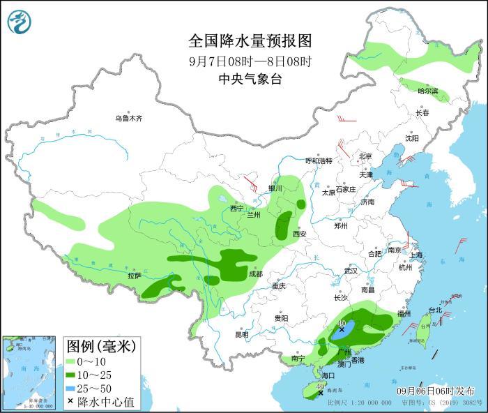
Figure 2 National precipitation forecast map (08:00 on September 7th – 08:00 on September 8th)
From 08:00 on September 8 to 08:00 on September 9, there were sleet in parts of northern Tibet and southern Qinghai, southeastern Tibet, southern Sichuan, northwestern Yunnan, southern Hunan, southwestern Jiangxi, central and western Guangdong, and central Guangxi. There are moderate rains in parts of the east and other places. Among them, there are heavy rains (25-40 mm) in parts of southeastern Tibet, southern Hunan, southern Sichuan, northwestern Yunnan, eastern and southeastern Guangxi, and western and northern Guangdong. There are 4-5 winds in parts of western Heilongjiang, Liaodong Peninsula, northern Hebei and other places (see Figure 3).
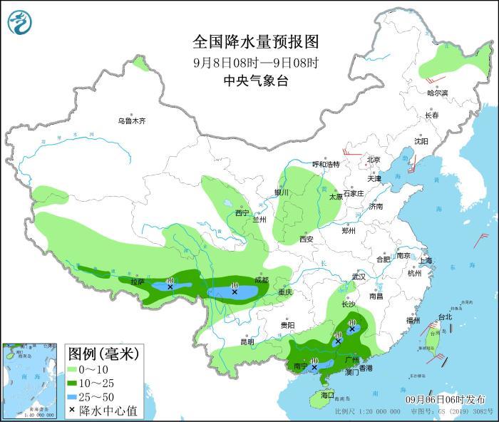
Figure 3 National precipitation forecast map (08:00 on September 8 – 08:00 on September 9)