
one,Heavy rains in parts of Sichuan, Chongqing, Zhejiang and other places The high temperature range reduces the strength
During the day today, there were heavy to heavy rains in parts of northeastern Sichuan, northern Chongqing, western Zhejiang, northeastern Jiangxi, and central Guangdong, and some heavy rains (100-114 mm) in Sichuan and Chongqing; the maximum hourly rainfall in the above-mentioned areas was 30-66 mm .
The high temperature range was further reduced and the intensity weakened compared with yesterday. High temperature weather above 35°C occurred in eastern Guizhou, Guangxi, southwestern Hunan, central and southern Jiangxi, Fujian, and central and southern Zhejiang, and 40-40.7°C in Lishui, Zhejiang and Fuzhou, Fujian.
Second, the key weather forecast
1、More rainfall in the eastern and southwestern regions of the Qinghai-Tibet Plateau
In the next three days, there will be cloudy and rainy weather in Qinghai, central and eastern Tibet, Sichuan, Chongqing, Guizhou, Yunnan and other places. Among them, from the night of August 30 to 31, the western Sichuan Plateau, Yunnan, southwestern and eastern Guizhou, and southern South China will be rainy. In some areas, there will be moderate to heavy rain, local heavy rain, accompanied by strong convective weather such as short-term heavy precipitation, thunderstorms and strong winds.
2、 The continuous high temperature weather process in the southern region has ended
Since the high temperature range has been significantly reduced and the intensity has weakened, the high temperature yellow warning has been lifted.However, it is expected that during the day on August 31, there will still be high temperature weather of 35-39 ℃ in Fujian, southwestern Guangxi and other places.。The Central Meteorological Observatory lifted the high temperature yellow warning at 18:00 on August 30.
3. Specific forecast for the next three days
From 20:00 on August 30th to 20:00 on the 31st,Eastern Tibet, eastern and southern Qinghai, central Gansu, southern Shaanxi, central Anhui, southern Zhejiang, western Sichuan Plateau, northern Chongqing, northern and southwestern Yunnan, eastern and southern Guizhou, northwestern Hunan, southern Jiangxi, northern Fujian, eastern Guangxi, There are moderate to heavy rains in parts of western Guangdong and Hainan Island. Among them, there are heavy rains (50-90 mm) in parts of southern Sichuan and southern Hainan Island. There are 4-5 winds in parts of central Inner Mongolia, Liaodong Peninsula, Xinjiang along the Tianshan Mountains, southern Jiangsu, and eastern Fujian (see Figure 1).
Figure 1 National precipitation forecast map (20:00 on August 30th – 20:00 on August 31st)
From 20:00 on August 31st to 20:00 on September 1st,There were moderate to heavy rains in parts of eastern Tibet, southwestern Sichuan, northern Yunnan, western Guangxi, eastern Fujian, and Taiwan Island. Among them, there were local heavy rains (50-70 mm) in southeastern Tibet. There are 4-5 winds in parts of northeastern Heilongjiang. There will be northerly to northeasterly winds of magnitude 5 to 7 and gusts of magnitude 8 in most waters of the East China Sea, the Taiwan Strait, and the ocean east of Taiwan (see Figure 2).
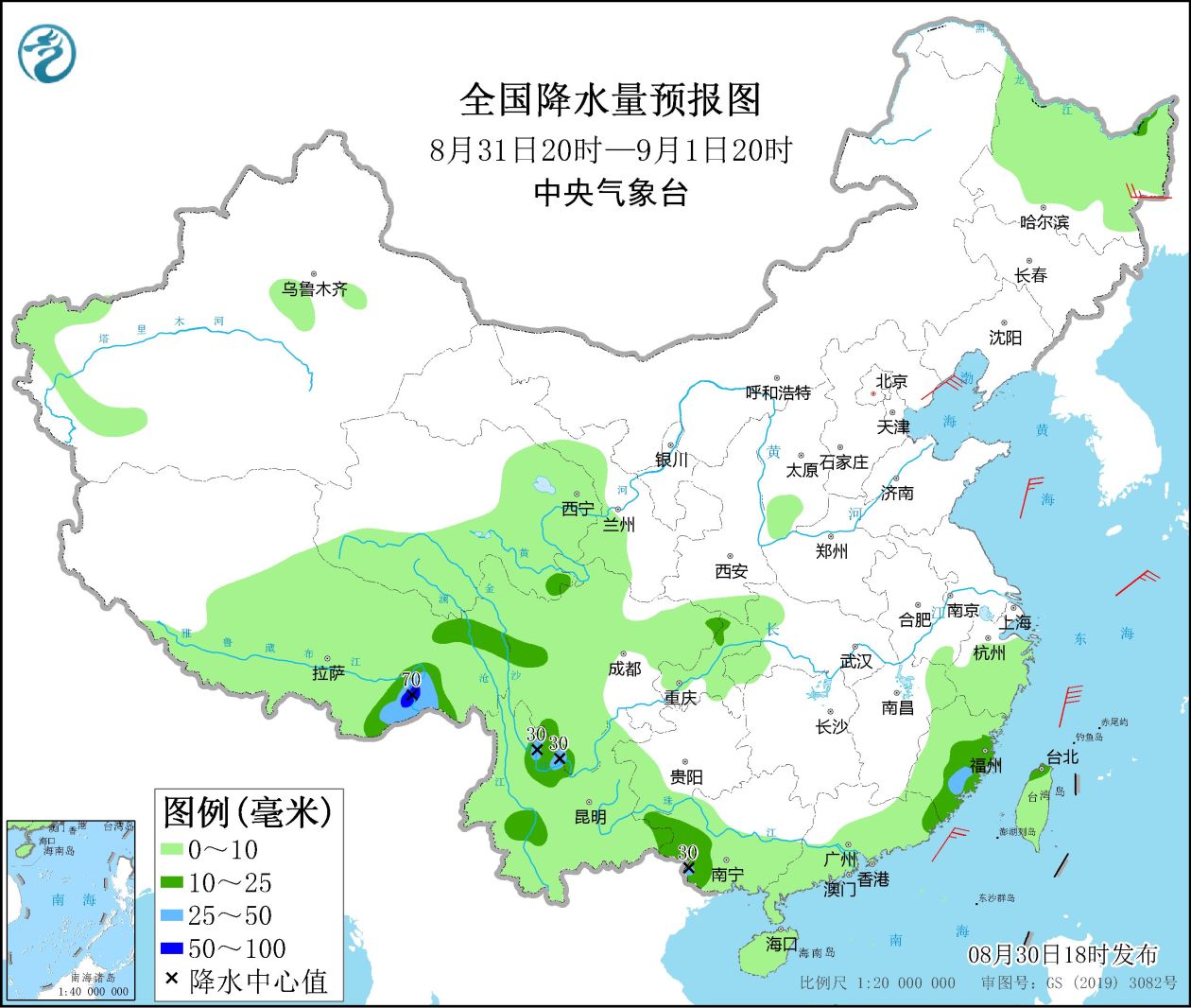
Figure 2 National precipitation forecast map (20:00 on August 31st – 20:00 on September 1st)
From 20:00 on September 1st to 20:00 on the 2nd,There are light to moderate rains in parts of central and eastern Tibet, central Northwest China, most of Southwest China, eastern Zhejiang, and Taiwan Island. Among them, there are heavy rains in parts of southern Qinghai, northwestern Sichuan, northern Taiwan Island, and southeastern Tibet. , local heavy rain (50 ~ 70 mm). There will be northerly winds of magnitude 8 to 10 and gusts of magnitude 11 on the ocean to the east of Taiwan (see Figure 3).
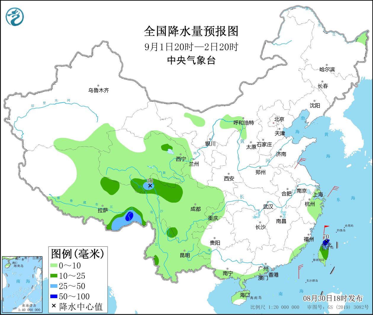
Figure 3 National precipitation forecast map (20:00 on September 1st – 20:00 on September 2nd)
4. Influence and Concern
1. Sichuan, Chongqing, the eastern part of the Qinghai-Tibet Plateau and other places have more rainfall, and pay attention to the possible secondary disasters;
2. Pay attention to the development trend of typhoon “Xuanlannuo” and the impact of wind and rain;
3. Pay attention to the changing trends and impacts of meteorological droughts from the Sichuan Basin to the middle and lower reaches of the Yangtze River.