
Today and tomorrow (July 31 to August 1), the impact of Typhoon “Sunda” on my country is mainly due to strong winds at sea, and some sea areas such as the East China Sea and the Yellow Sea need to guard against strong winds. With the approach of “Sanda” and the eastward withdrawal of the subtropical high, the high temperature in the south has decreased. Today, the highest temperature in Jiangnan and South China is mostly below 38 ℃. Next week, the subtropical high will strengthen to the west again, the high temperature range will expand northward, and the high temperature will reappear in southern North China, Huanghuai and other places.
Typhoon “Sanda” may swirl less in the offshore areas, such as the Yellow Sea in the East China Sea and other parts of the sea, and need to guard against strong winds
Yesterday, due to the influence of this year’s No. 5 typhoon “Sanda” and its surrounding cloud systems, heavy rainfall occurred in Jiangsu, Shanghai and other places. Monitoring shows that the central and eastern Shandong, northeastern and southern Anhui, northern and southern Jiangsu, Shanghai, Zhejiang , northern Fujian, central and western Guangdong and other local areas have scattered heavy to heavy rains, and local heavy rains have occurred in Yantai and Dongying in Shandong, and Lianyungang in Jiangsu.
At 5 o’clock this morning, the center of typhoon “Sanda” was located on the southern part of the Yellow Sea, about 285 kilometers east of Yancheng, Jiangsu, with a maximum wind force of magnitude 8 near the center. The Central Meteorological Observatory predicts that “Sanda” will move slowly to the west-north at a speed of 5-10 kilometers per hour during the daytime, with little change in intensity, and will begin to move in the east-north direction at night, with the speed increasing and the intensity gradually weakening.
Today and tomorrow, the impact of typhoon “Sanda” on my country is mainly due to strong sea winds. The Central Meteorological Observatory continued to issue a blue typhoon warning this morning. It is expected that there will be 6-7 winds along the coast of Shandong, Jiangsu, most of the Yellow Sea, and the northern and eastern parts of the East China Sea. , the wind force on the sea near the center of “Sanda” was 8, and the gust was 9-10.
Next week, the high temperature range will be expanded to the north, and the “Stuffy Sauna Day” in Huanghuai, North China will be launched
With the approach of “Sanda” and the eastward withdrawal of the subtropical high, the high temperature range and intensity in Jiangnan and South China decreased over the weekend, and the maximum temperature mostly dropped below 38°C.
Next week, the subtropical high will expand westward again, and the high temperature range will expand northward. Southern North China, southern Shaanxi, Huanghuai, Jianghan, western Jianghuai and other places will also join the ranks of high temperatures. And the humidity will also increase. In many places in North China and Huanghuai, the relative humidity can reach about 50% in the afternoon, and the local area is more than 60%. In addition, the high temperature in the Sichuan Basin will develop and intensify. For example, in Chongqing, the high temperature will continue for the next 7 days, and the maximum temperature will remain at 38~42℃.
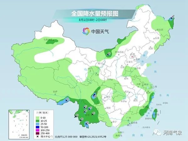
In terms of precipitation, today and tomorrow, the range of precipitation in my country is relatively wide, the rain is generally not strong, and there are local heavy rains in the southwest, northeast and other places. The Central Meteorological Observatory predicts that today, there will be moderate to heavy rain and local heavy rain in parts of northeastern Inner Mongolia, western Heilongjiang, eastern Jilin, Shandong Peninsula, southern Anhui, eastern Zhejiang, eastern Guangdong, southern Sichuan, and Yunnan.

Tomorrow, there will be moderate to heavy rains in parts of Xinjiang along the Tianshan Mountains, northeastern Heilongjiang, eastern Fujian, eastern Zhejiang, western Sichuan Basin, most of Yunnan, and Taiwan Island. Among them, there will be heavy rains in parts of western Sichuan Basin and other places.
Northeast and other places have experienced frequent rainfall recently. Attention should be paid to preventing the adverse effects of continuous rainfall on transportation and agriculture. The public should pay attention to traffic safety when traveling in rainy days.
Source: China Weather Network