
China News Service, July 31. According to the website of the Central Meteorological Observatory, affected by “Sanda”, from 08:00 on July 31 to 08:00 on August 1, the coastal areas of Shandong, Jiangsu, most of the Yellow Sea, the northern and eastern parts of the East China Sea will be affected. There were winds of magnitude 6 to 7. The wind force on the sea surface near the center of “Sanda” passed by magnitude 8, and gusts of magnitude 9 to 10; on July 31, there were still high temperature weather in Jiangnan and South China, but the intensity range was weakened compared with before.
Liaoning, Shandong, Jiangsu and other places appear scattered to heavy rains
From 08:00 yesterday to 06:00 today, central and southern Liaoning, central and eastern Shandong, northeastern and southern Anhui, northern and southern Jiangsu, Shanghai, Zhejiang, northern Fujian, northern Jiangxi, central and southern Hunan, western and southern Guizhou, central and western Guangdong, There were scattered and heavy rainstorms in northern Guangxi, Yunnan, southern Sichuan and northwestern Xinjiang, and local heavy rains (105-133 mm) in Yingkou, Liaoning, Yantai and Dongying in Shandong, Lianyungang in Jiangsu, and Lincang in Yunnan; The rainfall is 30 to 50 mm, and the local area exceeds 60 mm.
Yesterday, the high temperature in the southern region weakened. High temperature weather of 37-39 ℃ occurred in central and southern Zhejiang, eastern and southern Fujian, southern Jiangxi, central and northern Guangdong, eastern Sichuan, Chongqing and western Inner Mongolia, and eastern Xinjiang. Chongqing, Xinjiang Turpan Bureau above 40°C.
Typhoon “Sunda” affects the eastern sea area of my country
The center of this year’s No. 5 typhoon “Sanda” (tropical storm level) was located on the southern coast of the Yellow Sea, about 285 kilometers east of Yancheng, Jiangsu at 5 o’clock this morning. The lowest pressure is 995 hPa, and the radius of the seventh-level wind circle is 120-180 kilometers.
It is expected that “Sanda” will move slowly to the north-west at a speed of 5-10 kilometers per hour during the daytime, with little change in intensity. At night, it will start to move in the north-east direction, and the speed will increase and the intensity will gradually weaken. .
Affected by “Sanda”, from 08:00 on July 31 to 08:00 on August 1, there will be winds of magnitude 6 to 7 along the coast of Shandong, the coast of Jiangsu, most of the Yellow Sea, the northern and eastern parts of the East China Sea, and the center of “Sanda” will pass by. There are 8 winds on the nearby sea surface, and 9 to 10 gusts. There will be moderate to heavy rain in the eastern part of the Shandong Peninsula. The Central Meteorological Observatory continued to issue a blue typhoon warning at 06:00 on July 31.
This year’s No. 5 typhoon “Sanda” path probability forecast map for the next 36 hours
The high temperature in the Sichuan Basin of South China continues
On July 31, there were still high temperature weather in Jiangnan and South China, but the intensity range was weaker than before. From August 1, the high temperature range will expand northward, and high temperature weather will also occur in southern North China, southern Shaanxi, Huanghuai, Jianghan, and western Jianghuai. In addition, there are many high temperatures in the Xinjiang Basin, western Inner Mongolia, and western Gansu.
It is expected that during the daytime on July 31, there will be high temperature weather above 35 ℃ in northwestern Inner Mongolia, eastern Xinjiang Southern Xinjiang Basin, Turpan, Gansu Hexi, Shaanxi Guanzhong, western Hubei, Jiangnan, southern China, eastern Sichuan, and Chongqing. , the eastern part of the southern Xinjiang Basin and Turpan, southern Hunan, central and southern Jiangxi, central and southern Zhejiang, most of Fujian, eastern Sichuan, western Chongqing, northeastern Guangxi, and central and northern Guangdong. The local temperature of the basin can reach above 40℃. . The Central Meteorological Observatory continued to issue a high temperature yellow warning at 06:00 on July 31.
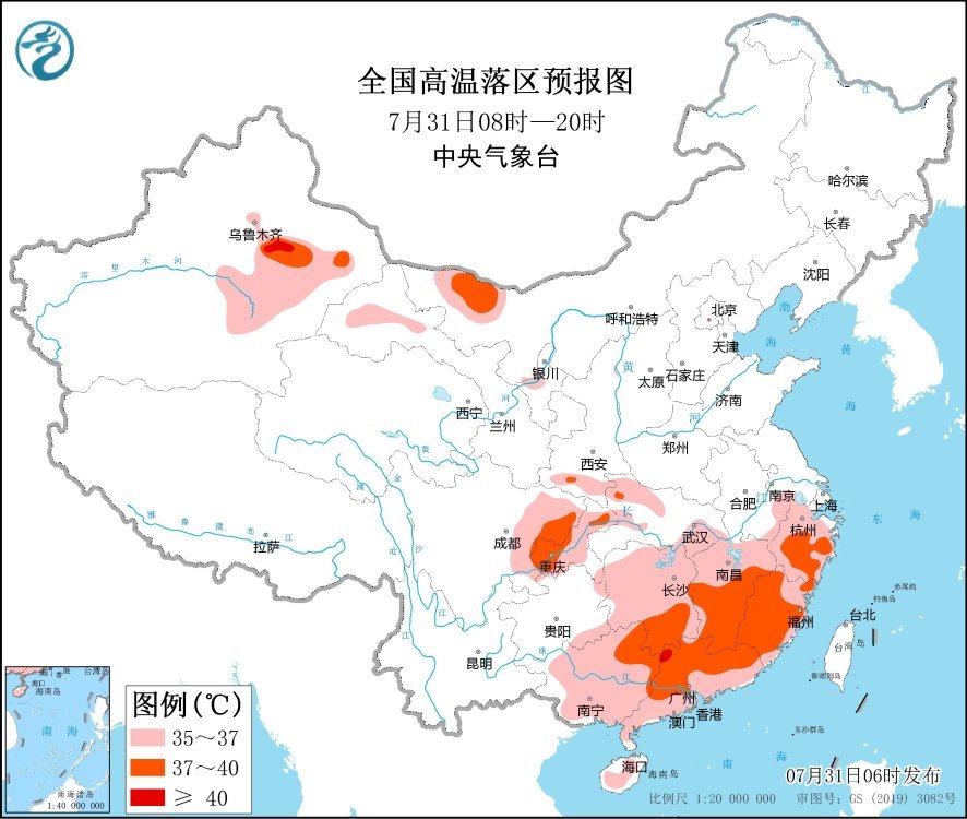
National high temperature forecast map (08:00-20:00 on July 31)
Specific forecast for the next three days
From 08:00 on July 31 to 08:00 on August 1, there were moderate to heavy rains in parts of northeastern Inner Mongolia, western Heilongjiang, eastern Jilin, Shandong Peninsula, southern Anhui, eastern Zhejiang, eastern Guangdong, southern Sichuan, and Yunnan. Local heavy rain (50-60 mm). There are 4-6 winds in central and western Inner Mongolia, Shandong Peninsula and other places.
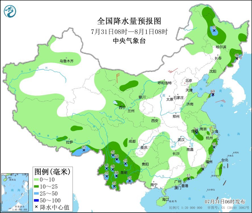
National precipitation forecast map (08:00 on July 31 – 08:00 on August 1)
From 08:00 on August 1 to 08:00 on August 2, there were moderate to heavy rains in parts of Xinjiang along the Tianshan Mountains, northeastern Heilongjiang, eastern Fujian, eastern Zhejiang, western Sichuan Basin, most of Yunnan, and Taiwan Island. Among them, the Sichuan Basin There are heavy rains (50-80 mm) in parts of the west and other places. There are 4-6 winds in central Inner Mongolia and parts of the Shandong Peninsula.
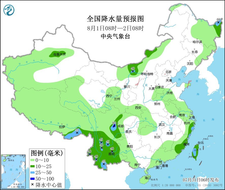
National precipitation forecast map (08:00 on August 1 – 08:00 on August 2)
From 08:00 on August 2 to 08:00 on August 3, there were moderate to heavy rains in parts of northeastern Inner Mongolia, southwestern Heilongjiang, southern Sichuan, Yunnan, southern Zhejiang, southern Jiangxi, Fujian, eastern Guangdong, Taiwan Island and other places. Among them, Yunnan There are heavy rains (50-80 mm) in parts of the southwest, southeastern Fujian, eastern Guangdong, and southeastern Taiwan Island. There are 4-6 winds in parts of eastern Inner Mongolia, eastern Xinjiang and other places.
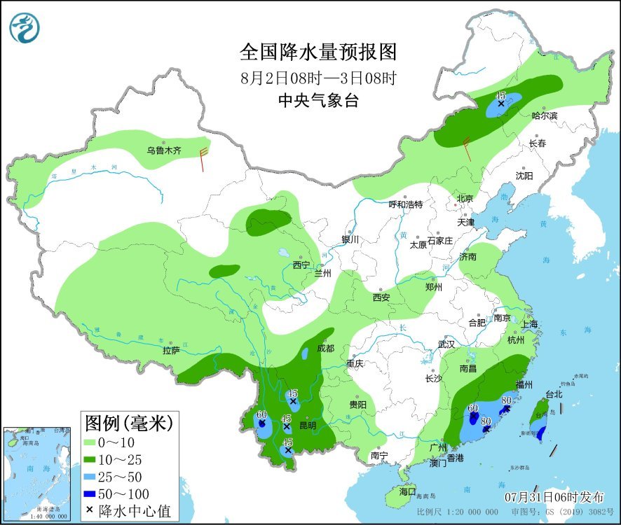
National precipitation forecast map (08:00 on August 2nd – 08:00 on August 3rd)