
Rainy and snowy weather in Southwest China and other places
There are smog in Huanghuai, Jianghuai and other places in the central and southern part of North China
1. Weather conditions
1. Domestic situation
(1)
There was rain and snow in the Southwest yesterday
From 08:00 yesterday to 06:00 today, light to moderate snow or sleet occurred in parts of northern Yunnan, northwestern Guizhou, southern Sichuan, and southeastern Qinghai; light rain and local moderate rain occurred in the Sichuan Basin, central Yunnan, and other places. In addition, affected by the cold air, at 05:00 today compared to 05:00 yesterday, parts of eastern Inner Mongolia, central Heilongjiang, central Jilin, and northern Liaoning experienced a 4-8°C drop in temperature, with a local drop of more than 10°C.
(2)
There are light to moderate haze in Huanghuai and other places in the south of North China this morning
This morning, light to moderate haze and local heavy haze appeared in southern Hebei, Shandong, Henan, central and northern Jiangsu and Anhui, eastern Hubei, and central Shaanxi.
2. Facts abroad
(1)
There was heavy rainfall in northern Australia, central and southern Africa, and there was heavy snowfall in the western United States
In the past 24 hours (00:00 on December 30, 2022 to 00:00 on December 31, 2022), Northern Europe, southern West Siberia, southwestern Canada, and the Midwest of the United States experienced light to moderate snowfall, with heavy snowfall in parts of the western United States. The Amazon Plain, the western part of the Brazilian plateau, Bolivia, central and southern Africa, northern Australia, and the southern coast of the United States experienced heavy to heavy rains and local heavy rains.
(2)
Higher temperatures in most of North America, eastern Europe
In the past 24 hours (00:00 on December 30, 2022 – 00:00 on December 31, 2022), the temperature in most of Canada, the central and eastern United States, and most of Europe has continued to rise, 2-4 ℃ higher than the same period of the previous year. Among them, Parts of eastern Canada, the eastern United States, and southern Europe were 6-8°C higher, and locally more than 10°C higher.
2. Key weather forecasts
1. Key domestic weather
(1) Rainy and snowy weather in Southwest China and other places
Affected by the southern branch trough and the cold air going south, from the 1st to the 3rd, there will be more cloudy, rainy and snowy weather in Southwest China and other places. Among them, parts of eastern Tibet, western Sichuan Plateau, eastern Northwest China, western Hubei, northern Yunnan, and northern Guizhou There is light snow or sleet in the area, and moderate snow locally; there is light rain in the Sichuan Basin, eastern Jianghan, and northern Jiangnan. In addition, in the next three days, some areas in northern Xinjiang will experience light to moderate snow and local heavy snow.
(2)
There are smog in Huanghuai, Jianghuai and other places in the central and southern part of North China
From the 1st to the 5th, the regional diffusion conditions in southern North China, Huanghuai and other places were poor, with light to moderate haze, and local heavy haze in western Shandong, Henan and other places. On the 6th, affected by the cold air, the diffusion conditions in most of the above-mentioned areas improved, and the haze weather weakened and dissipated.
2. Key foreign weather
(1) The temperature in most parts of North America is gradually rising
In the next three days, the temperature in most parts of North America will gradually rise, and the temperature will be 4~6℃ higher than normal in the same period. In addition, places such as Northern Europe, Eastern Europe, and the Midwest of the United States have light to moderate snow or sleet, and local heavy snowfall; places such as central and northern Argentina, eastern Philippines, southern Central Africa, and northeastern East Africa have heavy to heavy rain.
(2)
Tropical Storm “Darian” moving west-south
At 00:00 on the 31st (UTC), the tropical storm “Darian” is located at 30.3° south latitude, 68.1° east longitude, about 1560 kilometers southeast of Port Louis, Mauritius. Moving rapidly west-southward, the intensity weakened slowly. Affected by it, in the next three days, there will be light to moderate rain in north-central and southeastern Australia. Among them, parts of northern Australia will experience heavy to heavy rain and local heavy rain.
3. Specific forecast for the next three days
From 08:00 on January 1 to 08:00 on January 2,
There are light to moderate snow or sleet in parts of northern Xinjiang, eastern Tibet, eastern Qinghai, southern Gansu, southern Shaanxi, southwestern Henan, western Hubei, western Sichuan Plateau, and northern Yunnan. Among them, there is heavy snow in northern Xinjiang ( 5-7 mm). There were light to moderate rains in parts of southern Shaanxi, western Jianghuai, eastern Jianghan, northern Jiangnan, eastern and southern Southwest China, central and southern South China, and Taiwan Island. There are 4 to 5 winds in parts of central and eastern Inner Mongolia. The southern part of the East China Sea, the Taiwan Strait, the ocean to the east of Taiwan, the Bashi Channel, most of the South China Sea, the Qiongzhou Strait, and the Beibu Gulf will have northerly to northeasterly winds of magnitude 6-7 and gusts of magnitude 8-9. , Some sea areas in the northeast and southwest of the South China Sea can reach winds of magnitude 8-9 and gusts of magnitude 10. There will be northerly winds of magnitude 5-7 and gusts of magnitude 8 in the Bohai Sea, the Bohai Strait, the northern and eastern seas of the Yellow Sea, and the northern seas of the East China Sea. (see picture 1).
Figure 1 Precipitation forecast map across the country (from 08:00 on January 1st to 08:00 on January 2nd)
From 08:00 on January 2 to 08:00 on January 3,
There are light to moderate snow or sleet in parts of northern Xinjiang, northern and eastern Tibet, southern Qinghai, southern Shaanxi, southwestern Henan, western Hubei, western Sichuan plateau, and northeastern Yunnan. Among them, southeastern Tibet and eastern Sichuan plateau Locally there is heavy snow (5-9 mm). Southern Shaanxi, southern Anhui, most of Shanghai, southwestern Hubei, northwestern Hunan, northern Jiangxi, most of Zhejiang, northeastern Fujian, most of Sichuan Basin, Chongqing, most of Guizhou, central and eastern Yunnan, most of Guangxi, central Guangdong There was light rain in parts of the west, Hainan Island, Taiwan Island and other places. There are 4 to 5 winds in parts of central and eastern Inner Mongolia and central Heilongjiang. The southern part of the East China Sea, the Taiwan Strait, the ocean to the east of Taiwan, the Bashi Strait, most of the South China Sea, the Qiongzhou Strait, and the Beibu Gulf will have northerly to northeasterly winds of magnitude 6-7 and gusts of magnitude 8-9. , Some sea areas in the northeast and southwest of the South China Sea can reach winds of magnitude 8-9 and gusts of magnitude 10. There will be northerly winds of magnitude 5-7 and gusts of magnitude 8 in the Bohai Sea, the Bohai Strait, the northern and eastern seas of the Yellow Sea, and the northern seas of the East China Sea. (See Figure 2).

Figure 2 Precipitation forecast map across the country (from 08:00 on January 2 to 08:00 on January 3)
From 08:00 on January 3rd to 08:00 on January 4th,
There are light to moderate snow or sleet in parts of northern Xinjiang, northern and southeastern Tibet, central Qinghai, southern Ningxia, southern Gansu, central and southern Shaanxi, western Henan, and western Hubei. Among them, northern Xinjiang has locally As big as Blizzard (10-12mm). There was light rain in parts of southwestern Hubei, northwestern Hunan, central and southern Zhejiang, northeastern Fujian, most of the Sichuan Basin, Chongqing, most of Guizhou, northeastern Yunnan, most of Guangdong, and most of Taiwan Island. There are 4 to 5 winds in parts of northwestern Inner Mongolia and northern Heilongjiang. The southern part of the East China Sea, the Taiwan Strait, the ocean to the east of Taiwan, the Bashi Channel, most of the South China Sea, the Qiongzhou Strait, and the Beibu Gulf will have northerly to northeasterly winds of magnitude 6-7 and gusts of magnitude 8-9. , Some sea areas in the northeast and southwest of the South China Sea can reach winds of magnitude 8-9 and gusts of magnitude 10. There will be northerly winds of magnitude 5-7 and gusts of magnitude 8 in the Bohai Sea, the Bohai Strait, the northern and eastern seas of the Yellow Sea, and the northern seas of the East China Sea. (See Figure 3).
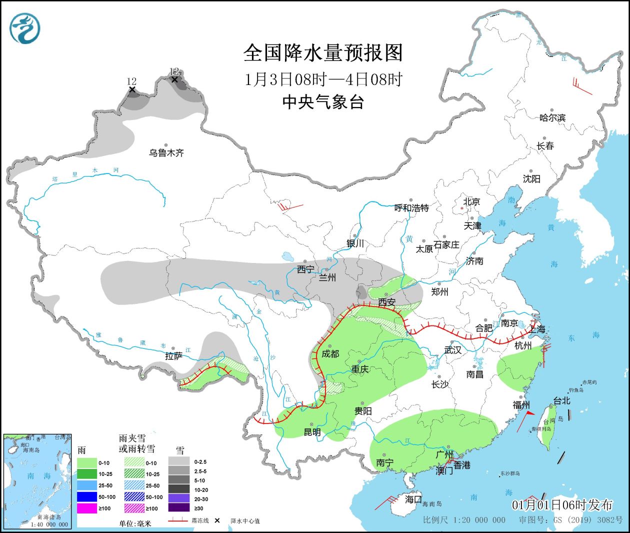
Figure 3 Precipitation forecast map across the country (from 08:00 on January 3rd to 08:00 on January 4th)