
1. Heavy rains and local heavy rains occurred in parts of Heilongjiang, Hebei, Shandong and other places High temperatures continue in the South
During the daytime today, there were heavy rains in parts of northeastern Heilongjiang, southeastern Hebei, northern Shandong, southern Guangxi, and southern Yunnan. There were local heavy rains in Shuangya Mountain in Heilongjiang, Hengshui in Hebei, Dezhou and Zibo in Shandong, and heavy rains in Ningjin, Dezhou, Shandong ( 109 mm).
High temperature weather above 37°C occurred in parts of the Sichuan Basin, southern Shaanxi, Jianghan, Jianghuai, and Jiangnan, among which 40-43°C in eastern Sichuan, central and western Chongqing, southeastern Shaanxi, central and western Hubei, most of Zhejiang, and Zhushan, Hubei. 43.1°C.
Second, the key weather forecast
1there is still more precipitation in the eastern part of the northwest region, northern China and western regions
From the night of the 22nd to the 24th, there will be moderate to heavy rains in eastern and northern Qinghai, central and southern Gansu, Ningxia, the Hetao area of Inner Mongolia, central and northern Shaanxi, Shanxi, southern Shandong, northern Jiangsu and Anhui, central and eastern Heilongjiang, and western and southern Yunnan. Local heavy rain or heavy rain, some of the above-mentioned areas will have short-term heavy precipitation, the hourly rainfall is 20-50 mm, and the local area can reach more than 60 mm; in addition, eastern Qinghai, western Henan, western Hubei, southern Zhejiang, southern Fujian, Guangdong There will be local thunderstorms, strong winds or hail in places like the east.
2Typhoon “Saddle” will affect the waters of southern my country
The center of this year’s No. 9 typhoon “Masa” (tropical storm level) is located on the Pacific Northwest Ocean about 325 kilometers northeast of Manila, Philippines at 5 pm today (22nd), which is 16.2 degrees north latitude and 123.5 degrees east longitude. The maximum wind force near the center is 8 (20 m/s), the lowest pressure in the center is 995 hPa, and the radius of the seventh-level wind circle is 160-200 kilometers.
It is expected that the “Saddle” will first move to the northwest at a speed of 10-15 kilometers per hour, and will move into the northeastern sea surface of the South China Sea in the early morning of the 24th, gradually approaching the coast of Guangdong, and its intensity will continue to increase. The strongest can reach the level of a severe tropical storm. (level 10-11, 25-30 m/s), and will land on the above-mentioned coast during the day on the 25th (23-28 m/s, level 9-10, tropical storm level or severe tropical storm level), the intensity after landfall gradually weakened.
Affected by it, it is expected that from 20:00 on the 22nd to 20:00 on the 23rd, there will be strong winds of magnitude 7-8 in the eastern sea area and the Bashi Strait in the northeast of the South China Sea. Grades 10-11.
picture1 The future of typhoon “Saddle”96Hourly path probability forecast map (8moon22Day17Time-26day 17Time)
3the Sichuan Basin, Jianghan, Jiangnan and other places have sustained high temperature
In the next three days, there will still be persistent high temperature weather in the Sichuan Basin, Jianghan, Jiangnan and other places. The highest temperature in the above-mentioned areas can reach 35-39 °C, and the local temperature can exceed 40 °C.
It is estimated that during the daytime on August 23, there will be 35 in southeastern Gansu, southern Shaanxi, southern Anhui, southern Jiangsu, Shanghai, Hubei, Hunan, Jiangxi, Zhejiang, Fujian, central and eastern Sichuan, Chongqing, eastern and northern Guizhou, Guangdong, and Guangxi. High temperature weather of ~39°C, among which, the highest temperature in parts of southern Shaanxi, eastern Sichuan, Chongqing, northern Hunan, central Jiangxi, central and eastern Zhejiang, and central Fujian can reach above 40°C (see Figure 2).Central Meteorological Observatory8moon23Day18Continue to issue a high temperature red warning.
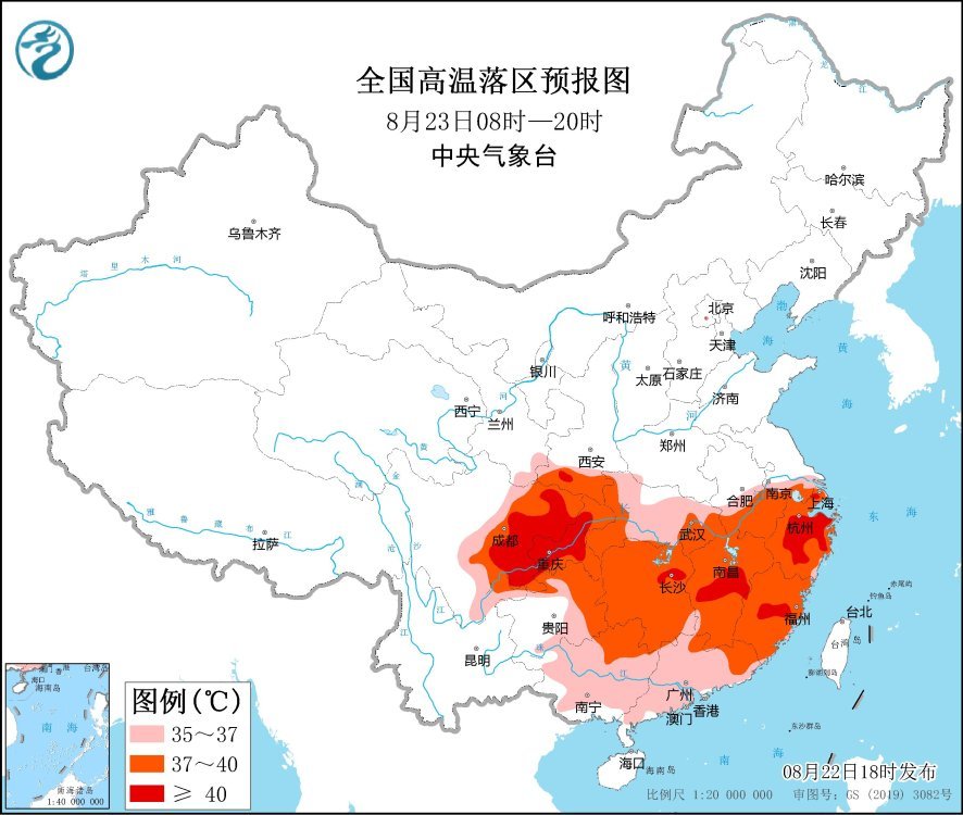
picture2 National high temperature drop area forecast map (8moon23Day08Time-20Time)
3. Specific forecast for the next three days
From 20:00 on August 22nd to 20:00 on the 23rd,Hetao area of Inner Mongolia, northeastern Heilongjiang, western mountainous areas of southern Xinjiang, northern and southeastern Tibet, northern and eastern Qinghai, Hexi of Gansu, northern Ningxia, northern Shaanxi, southern Shandong, eastern Henan, northern Anhui, northern Jiangsu, southern Fujian, Yunnan There are moderate to heavy rains in parts of the southwest and other places. Among them, there are heavy rains (50-70 mm) in parts of central and western Inner Mongolia, northern Jiangsu and other places; eastern Qinghai, western Henan, western Hubei, southern Zhejiang, southern Fujian, eastern Guangdong, etc. Locally there will be thunderstorms, strong winds or hail. There will be winds of magnitude 4 to 6 in parts of the southeastern and western parts of Inner Mongolia, Liaodong Peninsula, the southern and eastern Xinjiang Basin, northern Shaanxi, central and northern Henan, and northern Hubei, and there will be 6-7 winds in the Bohai Sea, Bohai Strait, and most of the Yellow Sea The northerly wind of magnitude 8 and 9 gusts (see Figure 3).
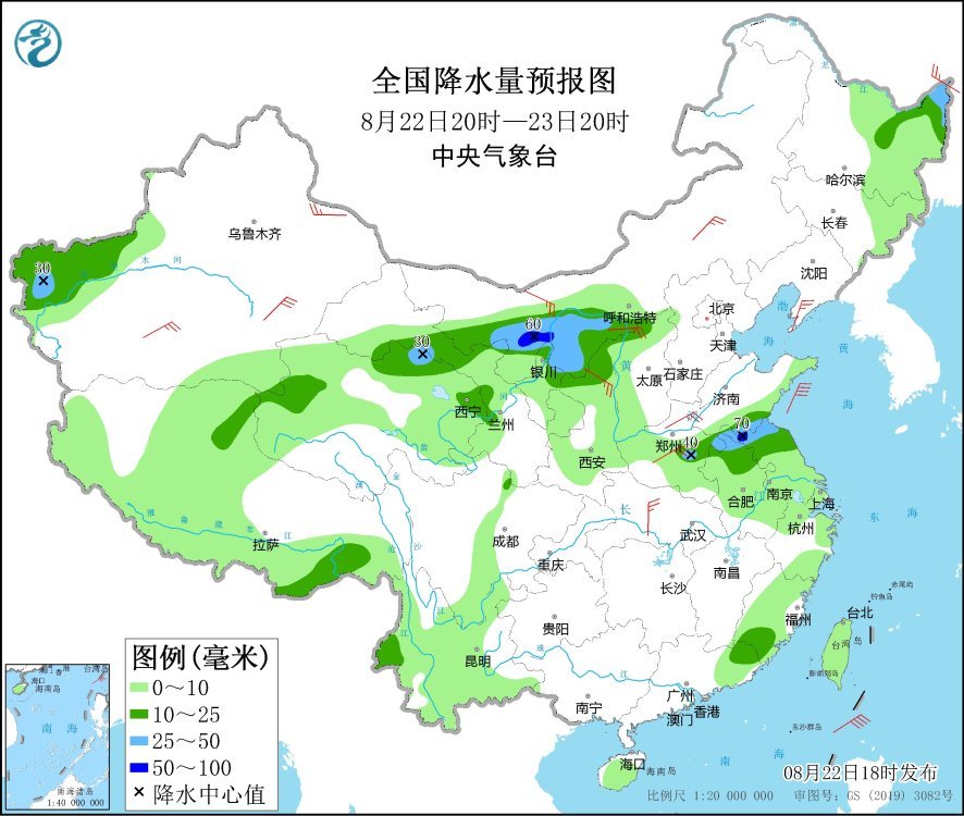
Figure 3 National precipitation forecast map (20:00 on August 22nd – 20:00 on August 23rd)
From 20:00 on August 23rd to 20:00 on the 24th,The Hetao area of Inner Mongolia, eastern Qinghai, central Gansu, western Ningxia, northern Shaanxi, central and northern Shanxi, central Jiangsu, southern Hunan, central and western Guangdong, and southern Taiwan Island experienced moderate rain. Among them, the Hetao area of Inner Mongolia, eastern Qinghai, There were heavy rains (25-40 mm) in parts of northern Shaanxi, western Shanxi, and central Jiangsu. There are 4-5 winds in parts of northeastern Heilongjiang (see Figure 4).
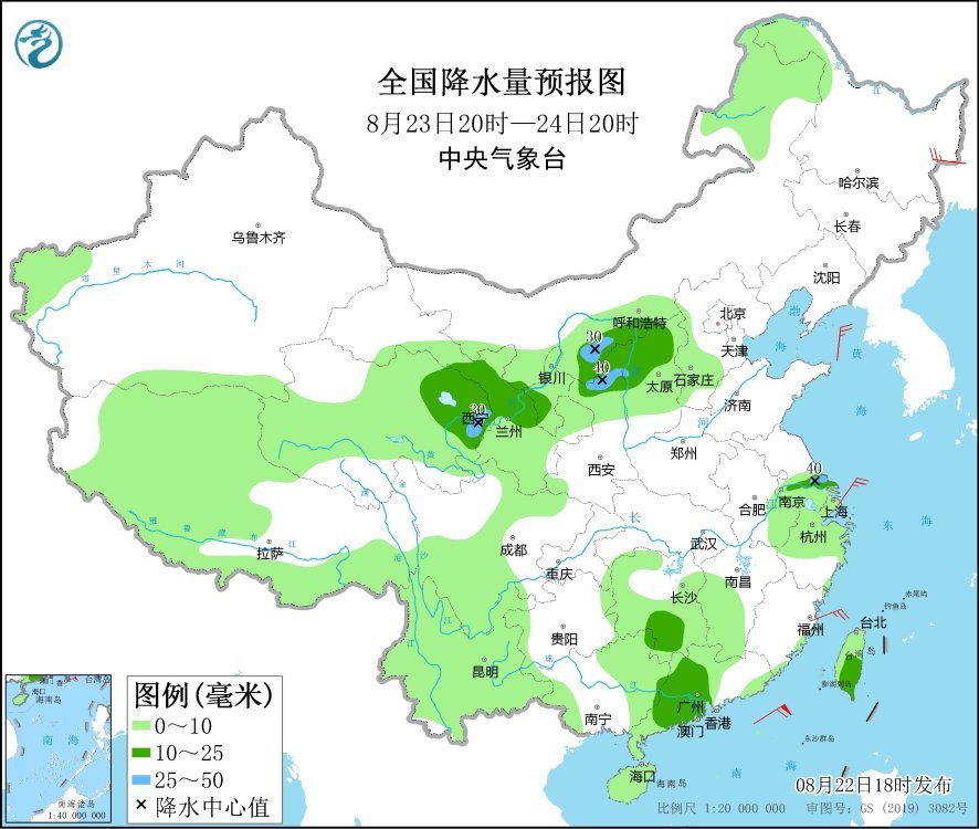
Figure 4 National precipitation forecast map (20:00 on August 23rd – 20:00 on August 24th)
From 20:00 on August 24th to 20:00 on the 25th,Northwestern Heilongjiang, western mountainous areas of southern Xinjiang, eastern Qinghai, southern Gansu, northern Sichuan, central Shaanxi, central and southern Shanxi, northern Henan, central and eastern Guangxi, Guangdong, southern Fujian, central Taiwan Island, northern Hainan Island, etc. Moderate to heavy rain, among which, there are heavy rains or heavy rains (100-200 mm) in parts of central and southern Guangdong. There are winds of magnitude 4 to 6 in parts of central Inner Mongolia, eastern Xinjiang and other places, and winds of magnitude 7 to 8 in parts of the coastal areas of southeastern Guangdong (see Figure 5).

Figure 5 National precipitation forecast map (20:00 on August 24th – 20:00 on August 25th)
4. Influence and Concern
1. There is a lot of rainfall in the eastern part of Northwest China, North China and other places. It is necessary to prevent the adverse effects of continuous rainfall and local short-term heavy rainfall on transportation and urban operation, and strengthen the prevention of local strong convective weather hazards;
2. Pay attention to the future development trend of “Saddle” and prevent the hazards of typhoons;
3. Pay attention to the development trend of high temperature in the southern region and its adverse effects on energy supply, water resources allocation, sanitation and epidemic prevention, and human health;
4. Development trends and impacts of drought conditions from the Sichuan Basin to the middle and lower reaches of the Yangtze River.