1. Weather
1domestic reality
Heavy rainfall in Sichuan, Chongqing, Guizhou, Zhejiang and other places:From 08:00 yesterday to 06:00 today, there were heavy to heavy rains in parts of northeastern and southern Sichuan, northern Chongqing, southern Shaanxi, northwestern Hubei, southwestern and eastern Guizhou, central and western Guangdong, southern Hainan Island, and central and southern Zhejiang. Local heavy rains (100-145 mm) in Dazhou of Sichuan, Kaixian County of Chongqing, Liupanshui and southwestern Guizhou of Guizhou, Ningbo and Lishui of Zhejiang, etc.; the maximum hourly rainfall in the above-mentioned areas is 30-80 mm.
High temperatures above 35°C occurred in southeastern Guizhou, southwestern Hunan, central and northern Guangxi, northeastern Guangdong, central and southern Jiangxi, Fujian, and central and southern Zhejiang, and local 38-40.7°C in southern Zhejiang and northern Fujian.
2. Live abroad
Strong precipitation in Pakistan, western Canada and other places: There are moderate to heavy rains in India, Pakistan, Indochina Peninsula, Greater Sunda Islands, New Guinea, the Far East, Japan, Northern Europe, West Africa, northern Central Africa, northern East Africa, western Canada, the central and eastern United States, and northern South America. Heavy rain or heavy rain accompanied by strong convective weather such as thunderstorms and strong winds.
High temperatures continue in West Asia, North Africa, the western United States and other places: High temperature weather above 35℃ occurred in West Asia, southern Central Asia, Indus Plain, northern Indochina Peninsula, North Africa, western southern Europe, southern Eastern Europe, Midwestern United States, northern Mexico, and central Brazil. Among them, Arabian Peninsula, Mesopotamia The daily maximum temperature in the sub-plain, southern Iran Plateau, North Africa, western United States, northern Mexico and other places reached 38-42 °C, with local temperatures exceeding 42 °C.
Second, the key weather forecast
1. Domestic key weather
(1) There is more rainfall in the eastern and southwestern regions of the Qinghai-Tibet Plateau and other places
On August 31, there were moderate to heavy rains and local heavy rains in parts of the western Sichuan Plateau, Yunnan, southern China and other places, accompanied by strong convective weather such as short-term heavy precipitation, thunderstorms and strong winds.
From September 2 to 4, there will be light to moderate rains and local heavy rains in eastern Qinghai, southern Gansu, Sichuan, Chongqing, Guizhou, and Yunnan.
Typhoon “Xuanlannuo” will affectEast my country Sea
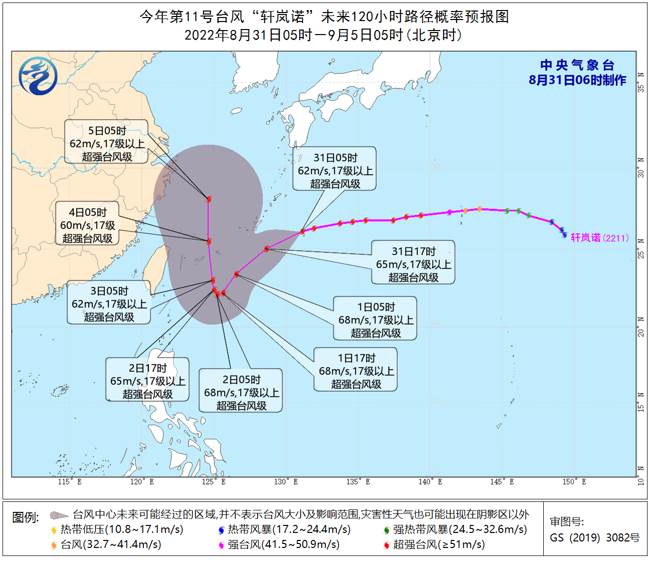
The center of this year’s No. 11 typhoon “Xuan Lannuo” (super typhoon level) is located on the northwestern Pacific Ocean about 340 kilometers east of Naha, Okinawa, Japan at 5 o’clock in the morning today (31st). Near the center, the largest The wind force is above level 17 (62 m/s), the minimum central pressure is 915 hPa, the radius of the seventh-level wind circle is 220-230 kilometers, the tenth-level wind circle radius is 70 kilometers, and the twelve-level wind circle radius is 40 kilometers.
It is expected that “Xuan Lan Nuo” will move west-south and south-west at a speed of about 30 kilometers per hour. From September 1 to 2, it will stagnate or circle in the ocean to the east of the Ryukyu Islands, and then turn to move north-west. On the night of the 3rd, it moved into the southeastern part of the East China Sea. In the next 4 to 5 days, “Xuanlannuo” will maintain the intensity of super typhoon level, and the maximum intensity can reach above level 17 (62-70 m/s).
Affected by it, from the daytime of the 31st to the night of September 2nd, there will be northerly winds of magnitude 6-8 and gusts of magnitude 9-10 in the southern waters of the Yellow Sea, most of the East China Sea, the Taiwan Strait, the ocean to the east of Taiwan, and the Bashi Strait. Among them, the southeastern waters of the East China Sea and the eastern seas east of Taiwan can reach winds of magnitude 9-12 and gusts of magnitude 13-14.
picture1 this year’s11The future of typhoon “Xuanlannuo”120Hourly Path Probability Forecast Map
2. Foreign key weather
(1) Strong precipitation on the Korean Peninsula, Canada and other places
In the next three days, the Ganges Plain, Indian Peninsula, Indochina Peninsula, Greater Sunda Islands, New Guinea, Korean Peninsula, Japanese Islands, Western Siberia, Central Siberia, Northern Europe, Eastern Europe, Canada, Eastern and Southern United States, Mexico, South There are moderate to heavy rains and local heavy rains in northern and northwestern America, central and eastern Australia, the South Island of New Zealand, West Africa, and northern Central Africa. Some of the above-mentioned areas are accompanied by strong convective weather such as thunderstorms and strong winds.
(2) Continued high temperature in West Asia and the western part of the United States
In the next three days, the Arabian Peninsula, Mesopotamia Plain, southern Iran Plateau, southern Eastern Europe, North Africa, western United States, central Brazil, central South America and other places will have high temperature weather above 35℃, and parts of West Asia, North Africa and other places will have high temperature weather above 35℃. The daily maximum temperature in the region exceeds 42°C.
3. Specific forecast for the next three days
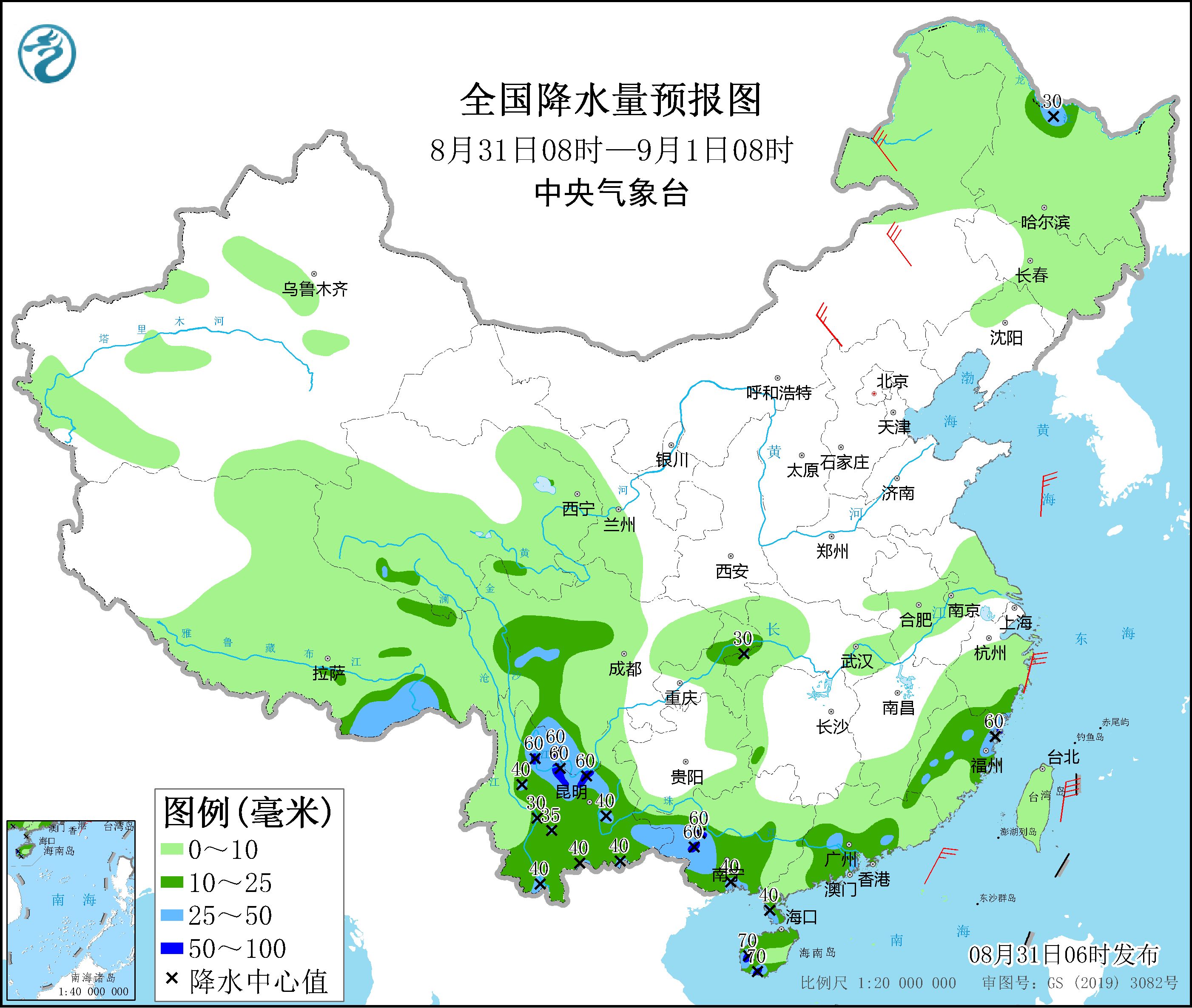
From 08:00 on August 31st to 08:00 on September 1st,There are moderate to heavy rains in parts of northwestern Heilongjiang, southeastern Tibet, western Sichuan Plateau, northern Chongqing, central and eastern Yunnan, central and western Guangxi, central and southwestern Guangdong, central and eastern Zhejiang, and northern and southwestern Hainan Island. , there are heavy rains (50-70 mm) in parts of southern Sichuan, northwestern and central and eastern Yunnan, southwestern Guangxi, and western Hainan Island. There are 4-6 winds in parts of northeastern and central Inner Mongolia and other places (see Figure 2). There will be northeasterly winds of magnitude 6 to 7 and gusts of magnitude 8 to 9 on the ocean to the east of Taiwan and the southern waters of the East China Sea.

Figure 2 National precipitation forecast map (08:00 on August 31st – 08:00 on September 1st)
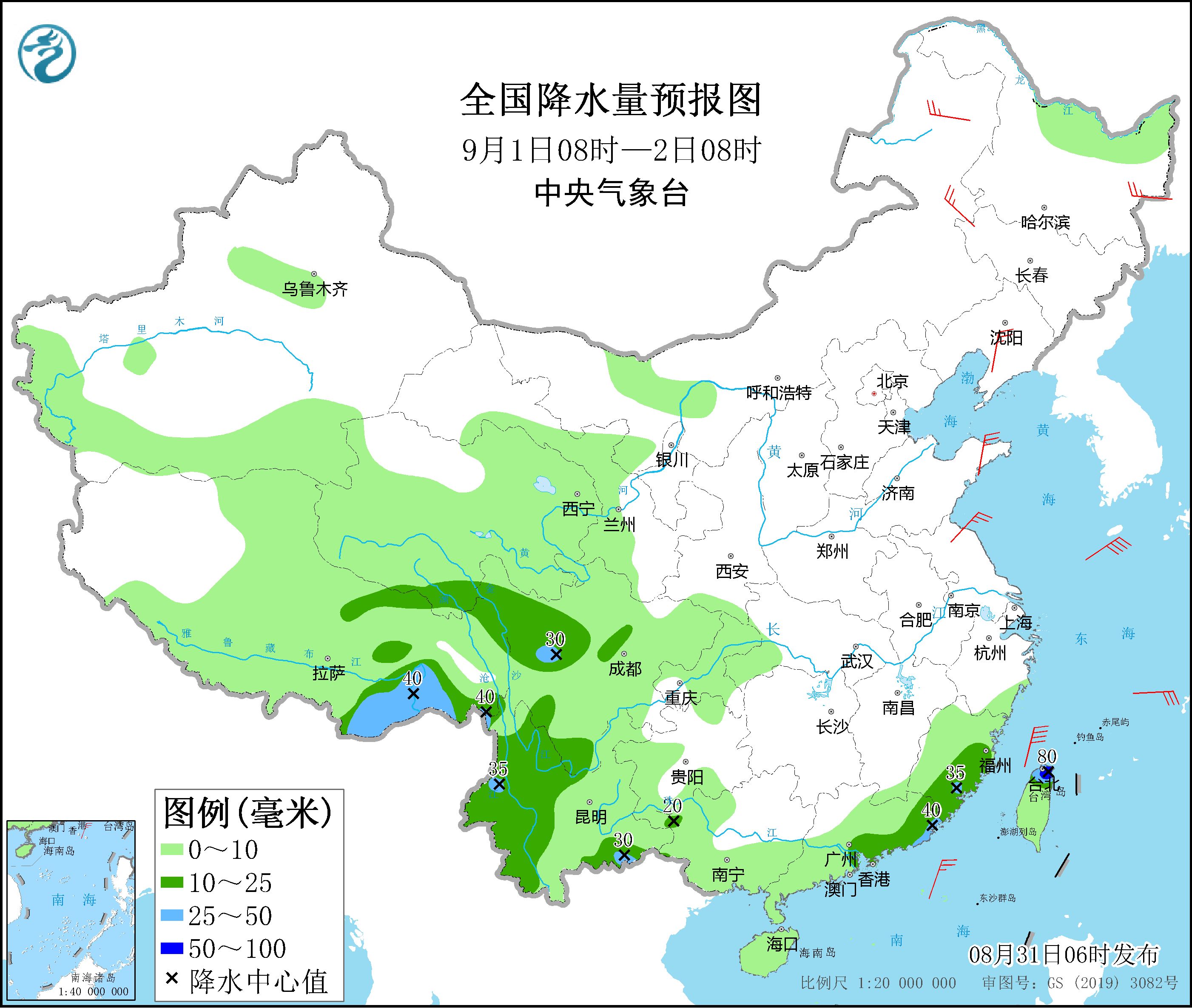
From 08:00 on September 1st to 08:00 on the 2nd,There are moderate to heavy rains in parts of southern and eastern Tibet, southern Qinghai, southeastern Fujian, southeastern Guangdong, central, western and southeastern Yunnan, western Guangxi, and northern Taiwan Island. Among them, there are heavy rains in parts of northern Taiwan Island and other places ( 50 to 80 mm). There are 4-5 winds in parts of eastern Inner Mongolia, northeastern Heilongjiang, central Liaoning, Shandong Peninsula and other places (see Figure 3). There will be northerly winds of magnitude 7 to 9 and gusts of magnitude 10 on the ocean to the east of Taiwan.

Figure 3 National precipitation forecast map (08:00 on September 1 – 08:00 on September 2)
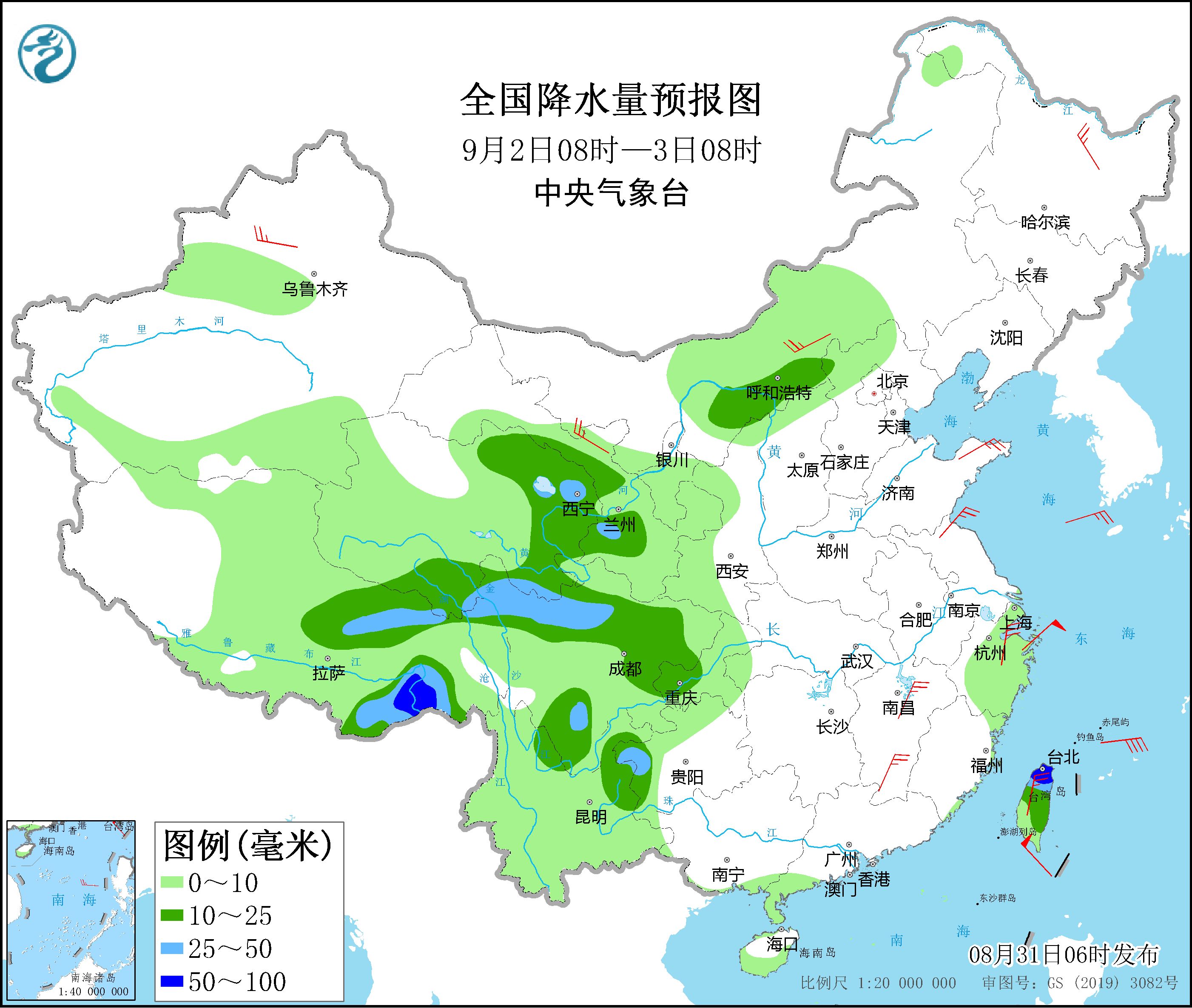
From 08:00 on September 2 to 08:00 on the 3rd,There are moderate to heavy rains in parts of the Hetao area of Inner Mongolia, northern and eastern Tibet, eastern and southern Qinghai, western and central Gansu, northern and southeastern Sichuan, southern Chongqing, northeastern Yunnan, and most of Taiwan Island. Among them, southeastern Tibet , There are heavy rains (50-90 mm) in parts of the northern part of Taiwan Island and other places. There are 4-6 winds in parts of central Inner Mongolia, northeastern Heilongjiang, Xinjiang along the Tianshan Mountains, Hexi in Gansu, Shandong Peninsula, northern and southern Jiangxi, northern Zhejiang, and central Taiwan Island (see Figure 4). There will be northeasterly winds of magnitude 12 to 13 and gusts of magnitude 14 on the ocean to the east of Taiwan.

Figure 4 National precipitation forecast map (08:00 on September 2nd – 08:00 on September 3rd)
4. Influence and Concern
1. Sichuan, Chongqing, the eastern part of the Qinghai-Tibet Plateau and other places have more rainfall, and pay attention to the possible secondary disasters;
2. Pay attention to the development trend of typhoon “Xuanlannuo” and the impact of wind and rain;
3. Pay attention to the changing trends and impacts of meteorological droughts from the Sichuan Basin to the middle and lower reaches of the Yangtze River.
Make:Chen Shuang Xu Jun Lian Zhihua Issued: Fu Guerlain
[
责编:杨煜 ]
