
China News Service, August 23. According to the website of the Central Meteorological Observatory, due to the influence of typhoon “Saddle”, from 8:00 on the 23rd to 8:00 on the 24th, there will be 7-7 Strong winds of magnitude 8, the nearby sea areas or areas where the center of the “saddle” passes can reach magnitude 9 to 10, and gusts of magnitude 11 to 12. From the 25th to the 26th, there were heavy to heavy rains and local heavy rains in western Guangdong and coastal areas, Guangxi, southern Guizhou, and northeastern Yunnan.
There is still more precipitation in eastern Northwest China, North China and other places
From the 23rd to the 25th, there will be moderate to heavy rains, local heavy rains or heavy rains in the eastern and northern parts of Qinghai, central and southern Gansu, Ningxia, the Hetao area of Inner Mongolia, central and northern Shaanxi, Shanxi, northern Jiangsu and Anhui, and western and southern Yunnan. There will be short-term heavy precipitation in the region, with an hourly rainfall of 20-50 mm, and the local area can reach more than 60 mm; in addition, there will be local thunderstorms, strong winds or hail weather in eastern Qinghai, southern Fujian, and northeastern Guangdong.
From the 27th to the 30th, there were heavy to heavy rains and local heavy rains in central and eastern Gansu, southern Ningxia, most of Shaanxi, southern Shanxi, northern and western Sichuan Basin, Henan, northern Jiangsu and Anhui, and eastern Guizhou.
Typhoon “Saddle” will affect my country’s southern waters
The center of this year’s No. 9 typhoon “Masa” (tropical storm level) is located on the northwestern Pacific Ocean, about 320 kilometers northeast of Manila, Philippines, at 5 a.m. today (23rd). The maximum wind force near the center is 9 (23 meters) /sec), the central minimum pressure is 990 hPa, and the radius of the seventh-level wind circle is 180-240 kilometers.
It is expected that the “Saddle” will move to the northwest at a speed of about 20 kilometers per hour, and the intensity will not change much. It will gradually approach the coast of Guangdong after moving into the sea in the northeastern part of the South China Sea tomorrow morning, and its intensity will gradually increase. The strongest can reach the level of a severe tropical storm. (level 10-11, 25-30 m/s), and will make landfall on the above-mentioned coast during the day on the 25th (23-30 m/s, level 9-11, tropical storm level or severe tropical storm level), the intensity after landing gradually weakened.
Affected by it, from 08:00 on the 23rd to 08:00 on the 24th, there will be strong winds of magnitude 7 to 8 in the east-north waters of the South China Sea, the east-east waters of the central South China Sea, and the Bashi Strait. Up to 9 to 10, gusts 11 to 12. From the 25th to the 26th, there were heavy to heavy rains and local heavy rains in western Guangdong and coastal areas, Guangxi, southern Guizhou, and northeastern Yunnan.
Probability forecast map of typhoon “Masaan” in the next 72 hours (05:00 on August 23rd – 05:00 on August 26th)
There are still high temperatures in Jiangnan and other places in the Sichuan Basin
On the 23rd, high temperature weather will continue to occur in the Sichuan Basin, Jianghan, Jianghuai, Jiangnan and southern Shaanxi; from the 24th, the high temperature in Jianghan and Jianghuai will be basically relieved; from the 26th, the high temperature range in the Sichuan Basin and Jiangnan will be reduced and the intensity will be reduced. weakened and lifted in some areas.
It is estimated that during the daytime on August 23, there will be 35 in southeastern Gansu, southern Shaanxi, southern Anhui, southern Jiangsu, Shanghai, Hubei, Hunan, Jiangxi, Zhejiang, Fujian, central and eastern Sichuan, Chongqing, eastern and northern Guizhou, Guangdong, and Guangxi. High temperature weather of ~39°C, among which, the highest temperature in parts of southern Shaanxi, eastern Sichuan, Chongqing, northern Hunan, central Jiangxi, central and eastern Zhejiang, and central Fujian can reach above 40°C. The Central Meteorological Observatory continued to issue a high temperature red warning at 06:00 on August 23.
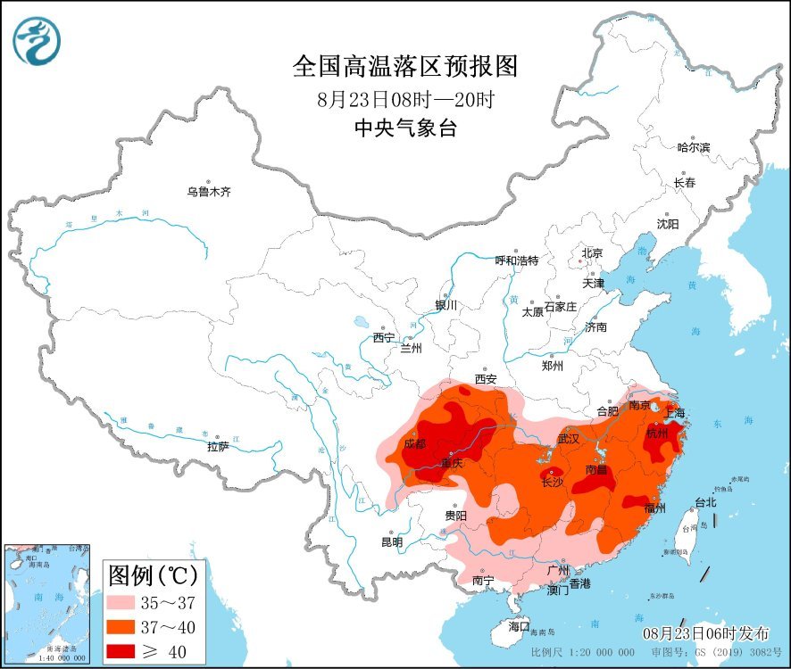
National high temperature forecast map (08:00-20:00 on August 23)
Specific forecast for the next three days
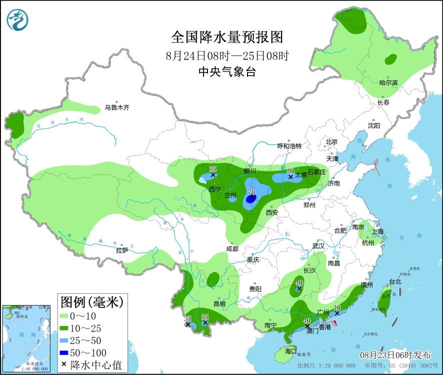
From 08:00 on August 23 to 08:00 on August 24, there were moderate to heavy rains in parts of northern and eastern Qinghai, Hexi, Ningxia, Inner Mongolia, central and northern Shaanxi, central and northern Shanxi, and southern Yunnan. Among them, the Hetao area of Inner Mongolia There will be heavy rains (50-70 mm) in some areas such as eastern Qinghai, southern Fujian, and northeastern Guangdong. There will be thunderstorms, strong winds or hail weather locally. There will be winds of magnitude 4 to 5 in parts of the southeastern part of the northwest region, Inner Mongolia, northeast China, and central Henan, and there will be northerly winds of magnitude 6 to 7 and gusts of magnitude 8 to 9 in the Bohai Sea, the Bohai Strait, and most of the Yellow Sea.

National precipitation forecast map (08:00 on August 23 – 08:00 on 24th)
From 08:00 on August 24th to 08:00 on August 25th, northwestern Heilongjiang, western mountainous areas of southern Xinjiang, eastern Qinghai, central and eastern Gansu, Ningxia, Shaanxi, southern North China, western and southern Yunnan, southern China, most of Taiwan Island and other places There are moderate to heavy rains in some areas. Among them, there are heavy rains (50-70 mm) in parts of southeastern Gansu and southern Ningxia.
National precipitation forecast map (08:00 on August 24th – 08:00 on August 25th)
From 08:00 on August 25 to 08:00 on August 26, there were moderate to heavy rains in parts of northwestern Heilongjiang, southeastern Northwest China, western Huanghuai, southern Jiangsu and Anhui, western Sichuan Basin, southern Yunnan, and most of southern China. Among them, There are heavy rains or heavy rains (100-200 mm) in parts of southern Guangxi, south-eastern Guangxi and other places. There are 4-6 winds in parts of eastern Inner Mongolia, Guangxi, Guangdong and other places.
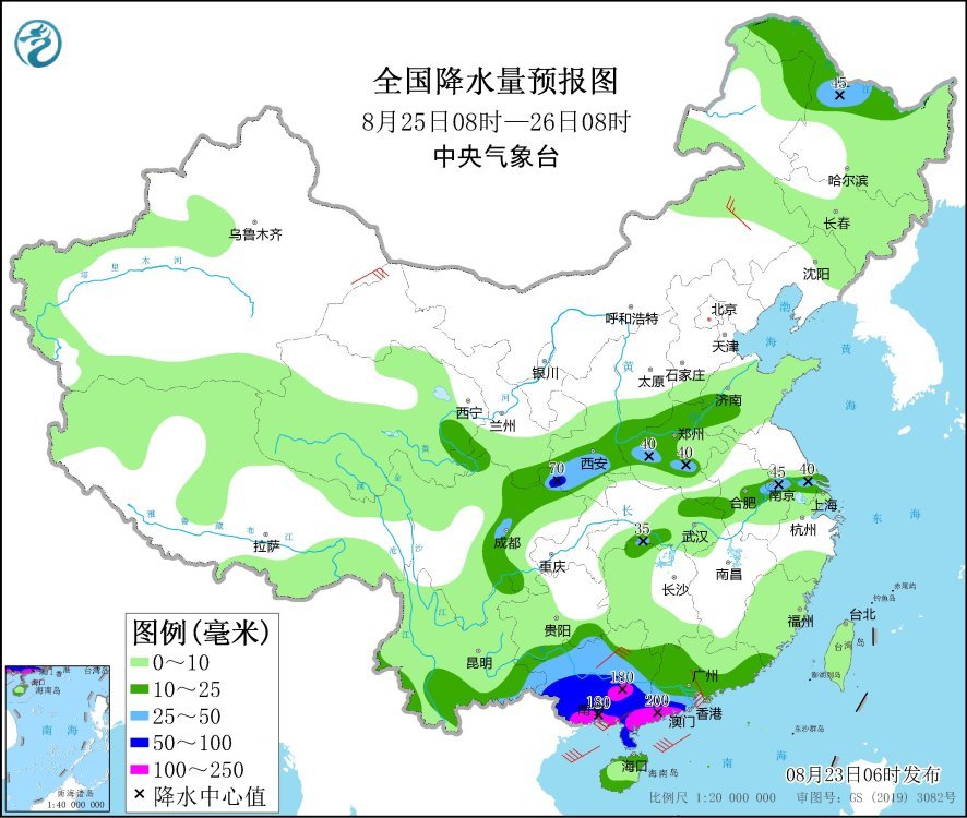
National precipitation forecast map (08:00 on August 25th – 08:00 on August 26th)