2 minutes, 38 seconds

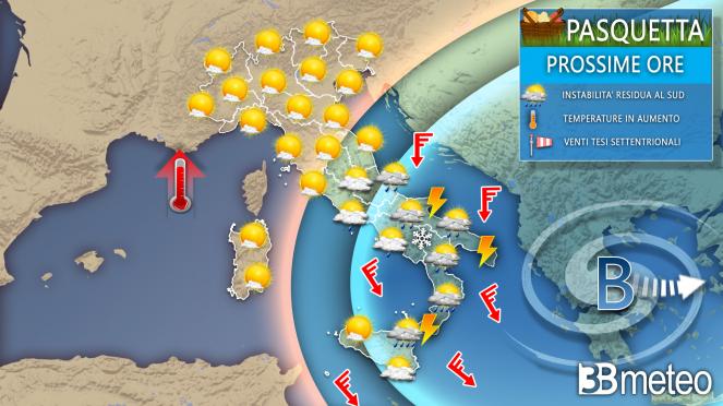
12.30 – GETTING BETTER ON THE MIDDLE ADRIATIC, STILL THUNDERSTORMS IN THE SOUTH, WINTER TEMPERATURES IN THE SOUTHERN – Although still in a context of variability, the weather is improving in the middle Adriatic after the showers and thunderstorms of the first part of the day. However, there is still a lot of instability in the South, although not everywhere. Campania, Basilicata and Sicily are freer while in Puglia and Calabria there are still many thunderstorms. The temperatures at 12:00 are emblematicsolo 8°C to Manfredonia, 7°C to Amendola (Foggia), 10°C in Bari and Brindisi, 11°C in Catanzaro, are all values for a normal February day. Milder values elsewhere with 15/17°C in the North and the central Tyrrhenian regions, up to 19°C in Sardinia.
The low pressure vortex which on Sunday brought widespread instability to the South and still some rain to the Center, moves further towards Greece but continues to attract cold air currents from the Balkans towards Italy. In the night a last impulse reached the regions of the middle and lower Adriatic side bringing gods showers and thunderstormsi with accumulations up to 22mm in the province of Bari and some too hailstorm. Due to the still rather low and below average temperatures the snow it fell on the reliefs of Calabria and Sicily up to 1200m but locally on the Nebrodi even at 1000m. Monte Sant’Angelo has also been whitewashed on the Gargano a 800m with a snowstorm.
Easter Monday with snow in Monte Sant’Angelo incredible and scary what do you think? #foggiaonline #fabius_fox #tiktokpakistan #tiktokindia #tik_tok #tiktok #only #MyDolceMoment #weperte #neipert pic.twitter.com/W3rTLs0X4f
— fabiusfox (@fabiusfox) April 10, 2023
Good morning and… happy Easter!!!#Easter Monday #neve pic.twitter.com/W9HqzJtDri
— Angelo Massimi (@AngeloMassimi) April 10, 2023
Over the next few hours this impulse will transit rapidly towards the southeast stimulating some more instability in the afternoon but following it the pressure will rapidly increase from the west. So a sunny Easter Monday for the central Tyrrhenian regions and for the whole North, a little residual instability in the middle Adriatic and lower Lazio, while in the South it will still take the whole day for showers and thunderstorms to completely abandon the scene. A short sunny break will follow then rain returns Wednesday. but let’s see a detail for the next few hours:

EASTERN WEATHER NEXT HOURS: Nord, scattered clouds in the morning in the Northwest but without phenomena, sunnier elsewhere. Afternoon with haze and thickening layers from the west with hazy sun but no rain. Evening with diffuse veils. center, variability and some last rainfall between low Marche and Abruzzo absorbed by the afternoon. Sunny on the Tyrrhenian coast even with a few blocks and brief showers in the afternoon on the lower Lazio. Clear everywhere in the evening. Sud, unstable in Molise, Puglia, Basilicata, Calabria and north-eastern Sicily with showers and thunderstorms interspersed with short clear spells. More sun in Campania and the rest of Sicily but with an afternoon that was sometimes unstable in inland areas and locally as far as the coast. Snow from 1000/1200m. Gradual attenuation of the phenomena between the evening and the night. Temperature slightly up in the Center and North. Northern winds with reinforcements in the south. Seas very moved in the southern basins, little moved or moved in the others.
To find out if a weather alert is in progress or expected in your area (rain, snow, ice, heat, wind and fog), consult our alert maps >> Alerts.
In the event of severe weather, storms with the risk of flooding/flash floods, there are some behaviors to follow to avoid serious dangers, including not underestimating the force of the water on the road during a flood. To know more. >> Here.
