
From the Universidad del Norte, the project was carried out in this municipality, with the participation of the Colombian Geological Service to “understand one of the most dangerous geological structures in the country.”
Huíla Newspaper, Wheels
By: Gloria Camargo
Researchers from the Universidad del Norte in Barranquilla, in collaboration with the Colombian Geological Service, have carried out a study on the “Neotectonics and paleoseismology of the Algeciras Fault, Huila, Colombia”. According to the academic coordinator of the Master’s in Earth Sciences, Professor Javier Idárraga García, the Algeciras Fault is one of the most important and dangerous geological structures in Colombia, due to its history of producing large earthquakes in the recent geological past.
The Eastern Andean Border Fault System, which extends from the Gulf of Guayaquil in Ecuador to the Caribbean coast of Venezuela, is known as the Algeciras Fault System in Colombia. This fault, which crosses several departments of the country, including Nariño, Putumayo, Cauca, Huila, Caquetá and Meta, has strong evidence of being an active geological fault, capable of generating earthquakes of significant magnitude.
According to Professor Javier Idárraga García and current academic coordinator of the Master’s in Earth Sciences, the “Algeciras Fault is one of the most important and dangerous geological structures in Colombia, since it has produced large earthquakes in the recent geological past, which which is of great importance for the national seismic hazard model”.
The Algeciras Fault, according to Idárraga, has compelling evidence that “it is an active geological fault, which generates earthquakes of significant magnitude, so it is of the utmost importance to study its seismogenic potential to advance knowledge of the threat and seismic risk in Colombia”.
academic research
The academic in turn pointed out that a neotectonics and paleoseismology study was carried out, led by the Colombian Geological Service, through the groups of Spatial Geodetic Research (Geohazards Directorate) and Geodynamics Research (Basic Geosciences Directorate), with the logistical support from the Pedagogical and Technological University of Colombia.
Apart from the SGC researchers, there was also the participation of scientists and collaborators from other Colombian and foreign institutions, including the Universidad del Norte.
time line
This study project began work in 2019, however it was stopped due to the Covid-19 pandemic, for which the book was published at the end of 2022. Being, according to the teacher, “the research is the most complete to date of a geological fault in Colombia, whose methodology integrated different types of data from multiple disciplines such as remote sensing, instrumental and historical seismology, geophysics, tectonic geomorphology, paleoseismology, among others”, he pointed out.
Regarding the field work in Huila, among other actions, a field campaign was carried out between the municipalities of Pitalito and Garzón, where morphotectonic cartography was checked on the ground and specific sites were identified for more detailed analysis.
Among the most important methodologies used to analyze the fault, a multidisciplinary and multiscale methodology stands out, “something that does not have many precedents in Colombia when they have wanted to study active faults,” he said.
The objective was to “determine and characterize the “big” earthquakes that the fault has produced in its most recent history (last 10,000 years). This discipline of geology that is in charge of identifying and describing prehistoric earthquakes (sometimes historical as well) is known as paleoseismology”, explained the academic coordinator.
Field work
Regarding the Algeciras Fault project, a regional analysis was carried out in relation to the Algeciras Fault project, which involved the municipalities of Pitalito and Garzón. Through aerial photographs, satellite images and digital terrain models, it was possible to map all the segments of the fault and it was determined that it is active, thanks to the identification of features in the landscape.
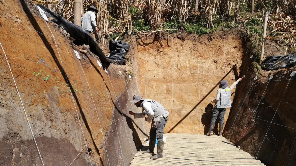
After selecting the sites of interest, geophysical surveys with electric tomography and drone flights were carried out to obtain images of the subsoil and terrain in greater detail. Two sites in the Miraflores village, jurisdiction of the Garzón municipality, were chosen for the opening of two paleoseismological exploration trenches, each one in a different branch of the Algeciras Fault.

In these trenches, a systematic process was carried out to record all the geological and structural information, which allowed establishing the occurrence time of the identified earthquakes and reconstructing the paleoseismological history of the Algeciras Fault in this sector. These advances will allow a better understanding of the seismic activity in the region and take preventive measures to minimize the damage caused by future earthquakes.
Study Results
With this study, it was possible to identify “fault traces that were not previously known and a very complete description of its geometry and kinematics was made. But undoubtedly the results with the greatest impact are those of the paleoseismological analysis, where several earthquakes of magnitudes between 7.2 and 7.4 were identified.
In the trench called Potrerillos, excavated in the Garzón branch, three paleearthquakes were differentiated, with an apparent recurrence period of 500-600 years and with dates of occurrence around 700 AD, 1300 AD and 1815 AD On the other hand, in the trench called Miraflores, excavated in the Tres Esquinas-Algeciras branch, three paleearthquakes were identified in the last 3000 years, with dates of occurrence in 1000 BC, a penultimate event with an uncertain date and a last one in the 20th century.
Something very interesting is that, preliminary, it seems that both branches of the Algeciras Fault have behaved independently from the seismogenic point of view, that is, each one has its own paleoseismic history. Referring to the last registered earthquake, both branches seem to have produced a historical earthquake: the Garzón branch seems responsible for the earthquake of November 16, 1827, while the Tres Esquinas-Algeciras branch originated the one on February 6, 1967. It is the first This is the time that the existence of evidence in the geological record of historical earthquakes is reported in Colombia,” he pointed out.
Regional and national impact
Referring to the implications and importance of this study for the seismic hazard model of Colombia, the academic pointed out that in the first place, it is absolutely necessary that “the results of this study should be included in the seismic hazard model for Colombia.”
“In particular, our study yielded a geologic dataset (e.g., coseismic displacement per event, averaged fault displacement rate, coseismic rupture length, time between events, time since last event, among others) that they are very important for the development of fault segmentation and seismic recurrence models, which constitute the modern foundation of probabilistic seismic hazard analysis,” he said.
Meanwhile, the communities that live near the fault must take into account several actions to prevent or mitigate the impact of an eventual earthquake, education being a key part.
“It is a pending account that we geologists, and scientists in general, have: to bring our discoveries to society in general in simple language, much more so if these studies have implications for the well-being of people and the development of the country.
One of the most beautiful activities of the project was the socialization that was made of it to the communities surrounding the sites of the excavations of the paleoseismological trenches. This was carried out by the researchers of the Colombian Geological Service, who explained the meaning of the fault passing through their territory and the implications regarding the probability of an earthquake, ”he indicated.
Regarding prevention, he added that basic research should be carried out on active geological faults, since he explained that it is impossible to have a robust and reliable seismic hazard model if the sources of the earthquakes are not known. An action that must be linked to socialization and education programs in the event of seismic events.
Finally, he pointed out that paleoseismological explorations should continue to be carried out in other segments of the fault, in previously identified sites and others that are identified in different sectors of the fault, especially towards the north of Meta and to the south, on the limits of Huila and Cauca, as well as in Putumayo and Nariño.