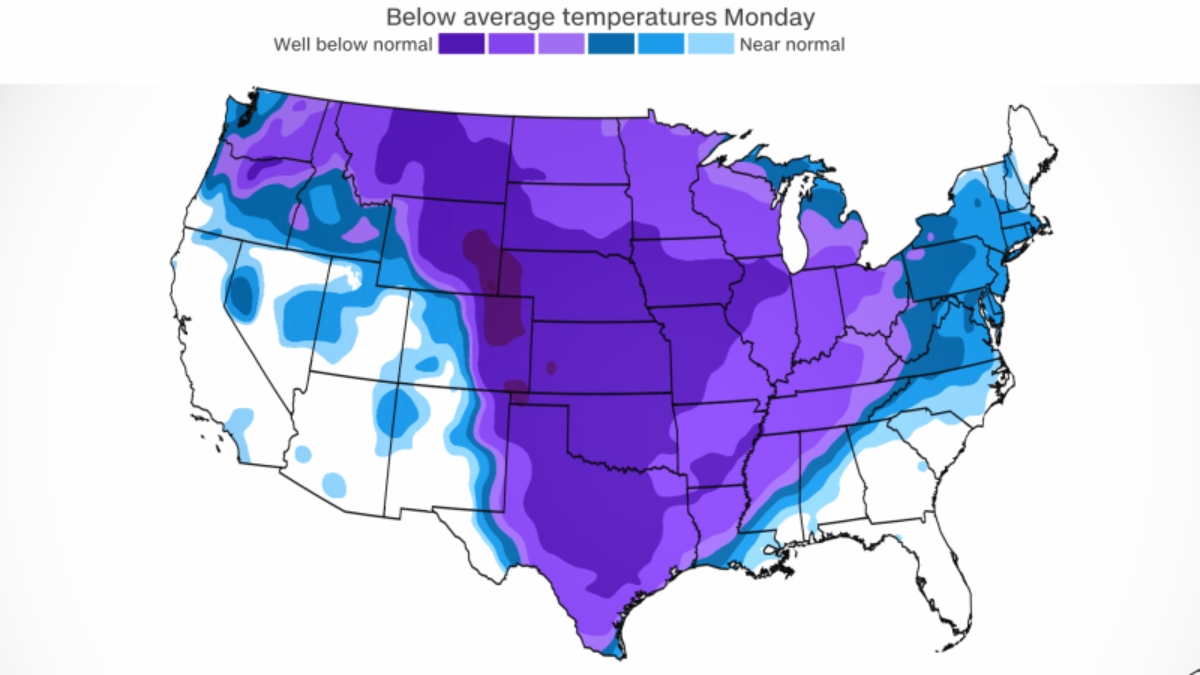
The Arctic cold snap currently gripping much of the United States will set the stage for shocking snow and ice to fall in parts of the South for the first time this winter as a new storm moves through the region.
The southern storm will be the fourth in the last two weeks that threatens to cause major impacts in areas east of the Rockies, as the frenetic start to 2024 shows no signs of stopping.
This Saturday, ice and wind combined with deadly results in Oregon. This Sunday, in Buffalo, New York, it was still snowing with lake effect; blinding snow squalls could occur in the northeast; and in the Midwest, strong winds continued to blow, stirring up snow and affecting travel.
But in the warmer South, everything has been tornadoes and strong storms. This is going to change with the arrival of the arctic cold to the region and much of the country.
More than 75% of the US population will experience freezing temperatures over the next seven days. As of Tuesday alone, more than 250 daily records for low temperatures could be broken, from Oregon to Mississippi. The cold will mean that this Monday the coldest electoral elections on record will be held in Iowa, with maximum temperatures below zero and a wind chill of -22 degrees.
Residents of Dallas, Nashville and Memphis, Tennessee, woke up to sub-zero temperatures this Sunday. This Tuesday, those same temperatures will reach Atlanta, Montgomery, Alabama and Shreveport, Louisiana.
In southern cities like Memphis, Dallas and Nashville, temperatures are expected to remain below freezing for at least 72 consecutive hours. The prolonged cold could cause “damage to exposed pipes and breaks in water mains are expected,” the National Weather Service office in Jackson, Mississippi, warned.
The extreme cold will also test Texas’ power grid for the first time this winter, which is highly vulnerable to extreme temperatures. Plummeting temperatures will increase demand for power on the grid enough that the state’s independent grid operator, ERCOT, issued a weather alert, warning of an imminent surge in demand and a possible decrease in reserves. ERCOT said there was expected to be enough power to avoid outages.
This Saturday in Montana a wind chill of -95 degrees was recorded. In the south it won’t feel as cold, but winds of 10 to 25 mph could cause life-threatening wind chills that could cause frostbite to exposed skin in as little as 30 minutes.
With cold air in place, a new system will move out of the Rocky Mountains and into the southern Plains bringing snow, sleet and freezing rain from Texas to Virginia.
Winter storm warnings extend from Texas to Virginia and cover more than 45 million people, including all of Tennessee and Arkansas.
“The prolonged nature of this event could result in potential moderate to significant winter storm impacts over portions of Arkansas, northwest Mississippi and western Tennessee,” the Weather Prediction Center said.
States of emergency were declared in both Arkansas and Louisiana before the arrival of the system.
Ice is one of the biggest concerns. A swath of sleet and freezing rain is expected from San Angelo, Texas, to Huntsville, Alabama. Dangerous ice could build up on roads, trees and power lines.
And because of the cold, slippery winter precipitation won’t melt on untreated surfaces for Monday morning commutes in places like Dallas and Shreveport, Louisiana, making trips more dangerous.
Dallas is expected to see a mix of freezing rain, sleet and snow from 3 pm this Sunday until 9 am this Monday. The calendar tilts a few hours later at points towards the east.
The storm will establish a layer of snow between 2 and 6 inches from Oklahoma to Virginia, just north of where the heaviest ice will fall.
Memphis, which has had no measurable snow so far this year, is expected to see between 3 and 7 inches. The threat begins this Sunday night and will continue throughout this Monday night.
Snow accumulations of 2 to 7 centimeters are also expected from Oklahoma City through Tulsa. Almost the entire state of Arkansas is expected to see at least 7 centimeters, with some places picking up up to 15 centimeters total. Snow accumulations of 3 to 5 inches are expected for Nashville and Knoxville, Tennessee.
The storm will clear the south late Tuesday and then could move into the mid-Atlantic and Northeast, increasing the chances of snow there on Wednesday.
CNN meteorologist Sara Tonks contributed to this report
