3 minutes, 9 seconds

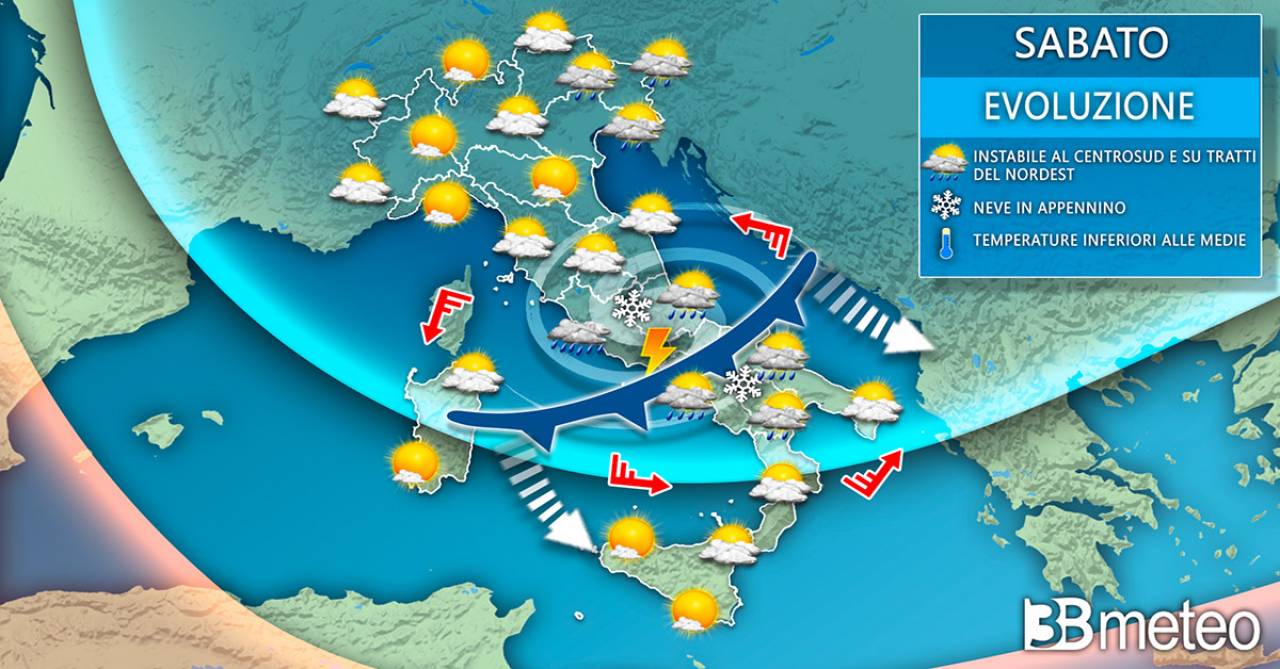
EASTER WEEKEND SOMETIMES UNSTABLE. The cold front coming from Northern Europe is reaching central-northern Italy will feed and keep active a depression area already present between the Adriatic and the Balkans. They will follow sometimes unstable conditions during the long Easter weekend in the central-southern regions, with the possibility of showers including thunderstorms, cool weather and snowfalls in the Apennines at medium-low altitudes for the period. It will be a little better in the North, where the influence of an anticyclone on central-western Europe will lead to more stable conditions. However, there will be some disturbances in the Northeast, especially in the first part of the weekend. Gradual reduction of instability starting from Easter Monday for the expansion of an anticyclonic headland from Western Europe.
THERE WILL BE NO SUNNY BREAKS. However, for the central-southern regions it will not be a rainy phase everywhere and continuously. The atmospheric instability that we will encounter in fact provides for the formation of showers and thunderstorms of a scattered nature and of limited duration, distributed in an extremely irregular way and alternating with sunny moments that will certainly not be missing. The downpour will hit in a chaotic way, hitting small areas and leaving dry areas, perhaps with sunnier conditions. The classic capricious and ‘unreliable’ weather that often characterizes the spring season: eyes therefore always aimed at the sky. In this article more details.
WEATHER SATURDAY 8 APRIL. It will initially be a sunny day in the North, apart from residual accumulations in the morning in the lower eastern Po Valley. During the day some variability will develop near the eastern Alps with some showers or local thunderstorms in the evening in the eastern Lombard, upper Veneto and Friuli VG plains. Splashes of snow in the mountains above 1300m. Local diurnal variability also in the western Piedmont Alps. Greater instability in the Central-South peninsular with showers already present in the morning in lower Tuscany, Lazio, Umbria and upper Campania, extending between the afternoon and evening in Abruzzo, the rest of Campania, Lucania, central-northern Puglia, upper Calabria. The phenomena could also take on a stormy nature, especially in the central hours between Lazio and Campania, locally of strong intensity and accompanied by hail. Snow quota in the Apennines around 1100/1300m. Sunniest on the main islands. Temperatures decreasing in the Central-South peninsular.

EASTER WEATHER. Mostly sunny in the north-west, Lombardy, western Emilia, greater variability in the rest of the north in the Alps, eastern Pre-Alps, high plains of Veneto and Friuli and in central-eastern Emilia with some scattered showers as early as the morning, but lessening during the day. Sprinkles of snow on the Eastern Alps up to around 900m in the morning, rising during the day. In the Center-South unstable already in the morning on the Adriatic side with scattered and intermittent showers from the Marches to Puglia, as well as on the north of Sicily, extending during the day to a large part of the Tyrrhenian side and also thunderstorms and snow on the Apennines from about 1300/1500m. In the evening gradual attenuation of the phenomena, with the exception of residues on the lower Tyrrhenian side. Some showers also in Sardinia in central-eastern areas, especially in the afternoon. Temperatures without great variations, generally below average.
EASTERN WEATHER. Some instability will still be present in the central-southern Adriatic regions and in the south with scattered and intermittent showers, also thunderstorms over central-eastern Sicily and Calabria, especially in the afternoon, but decreasing in the evening. Some snowfall on the southern Apennines and reliefs of Sicily from 13001400m. Sunnier in the North, in the regions of the middle-upper Tyrrhenian Sea, Campania and in Sardinia, but with a tendency in the evening to increase in cloudiness in the Northwest. Temperatures on the rise, especially in the North and on the upper Tyrrhenian Sea.
Want to know if there will be wind in your area? We also have national and regional wind maps available. Click here for details >> Twenty.
Even in high pressure conditions, in the middle of summer, thunderstorms can suddenly form and surprise us, short, localized but sometimes intense: they are the so-called ‘heat storms’ and are more likely between the late afternoon and early evening.