
The strong typhoon “Xuanlannuo” has affected the peripheral circulation from today, and the Hangzhou Provincial Defense Index has upgraded the emergency response to typhoon prevention to level III!
This year’s No. 11 typhoon “Xuanlannuo” was located at 12:00 today on the ocean east of Taiwan, about 975 kilometers east of Zhujiajian Island, Zhoushan City. The maximum wind force near the center was above 14 (45 m/s, strong typhoon ), it is expected that the typhoon will stagnate or revolve in the ocean east of Taiwan, and its intensity will weaken. It will turn to move northward from the 3rd, and move into the East China Sea on the night of the 3rd. Coastal movement along the northeast. The Provincial Meteorological Observatory has issued a maritime typhoon warning at 12:00.
According to the “Zhejiang Provincial Emergency Plan for Flood Control and Typhoon Prevention and Drought Relief”, the provincial defense index decided to upgrade the emergency response to typhoon prevention to level III at 14:00 on September 2.
The China Meteorological Administration launched a three-level typhoon emergency response on September 2, and the Central Meteorological Observatory issued a typhoon yellow warning at 10:00 on September 2.
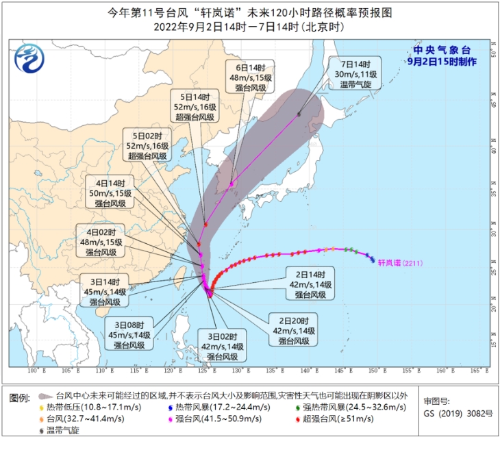
It is expected that “Xuanlannuo” will first stagnate or swirl in the ocean east of Taiwan, and its intensity will weaken slightly. It will turn to move north-westward from the 3rd, and move into the East China Sea at night on the 3rd, and its intensity will develop again. It is possible to develop into a super typhoon again and gradually approach the coast of northeastern Zhejiang.
From the night of the 4th to the morning of the 5th, it will turn to the northeast in the coastal waters of Zhejiang, and tend to the coast from the southern part of the Korean Peninsula to the Japanese island of Honshu.

The Municipal Meteorological Observatory predicts that according to the current weather model forecast, the subtropical high that traverses the east and west will weaken and break into two rings tonight. The deep V pace. Today, “Xuan Lan Nuo” gradually turned to move in a north-westerly direction, and moved into the southeastern sea surface of the East China Sea on the night of the 3rd.
However, due to the complexity of the current atmospheric circulation situation, during the turning period of “Xuanlannuo”, due to the interaction of the northward cold air moving eastward and the change of the subtropical high pressure, the path is still uncertain. However, affected by its peripheral circulation, today Hangzhou is located in a saddle-shaped field between the two ring sub-highs, and the middle and low layers are gradually affected by the typhoon inversion. The weather in the main city, Tonglu, Fuyang and Xiaoshan is moderate to heavy in a short period of time.
On the 3rd and 4th, as the typhoon approaches, the impact of wind and rain will be more obvious. There will be heavy rains and local heavy rains in parts of Qiantang District, Xiaoshan District, the main urban area, and the northwestern mountainous areas of Lin’an and Yuhang; There are strong winds of level 6-8 with individual levels above level 9.
Typhoon is a key factor in the weather for a period of time in the future. A small change will bring about a big change in the weather. Everyone should pay attention to the latest developments of typhoons and take precautions.
Source: Hangzhou + News Central Meteorological Observatory, Hangzhou Weather, etc. Author: Editor: Zheng Haiyun