Loading player
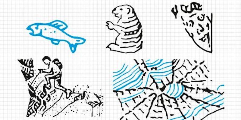
Until three years ago, the drawing of a marmot could be seen on the Swiss map of the Aletsch glacier in the cantons of Bern and Valais. It was not an optical effect due to the morphology of the mountains, as many thought, but the joke of a cartographer. Paul Ehrlich, who specializes in rock drawings, had made the marmot in 2011, shortly before retiring. He had tried various solutions before finding an illustration that did not obviously alter reality and with a subject linked to the surrounding environment.
(Swiss Topographic Office)
The marmot is not an isolated case: since the 1980s and until a few years ago several cartographers have hidden a spider, a man’s face, a hiker, a fish. Now the drawings have all been removed, even if their traces remain in the archives.
It is well known that maps are not an exact copy of reality, but projections, the most realistic possible representations of the reality to be depicted. Before the technological development and the massive use of data and satellite images, cartographers represented the territory by updating the old maps to follow the building development or linked to climate change, for example by drawing the expansion of a city or the deviation of a River. As has explained the federal office of topography of Switzerland, “during this work it can happen, even if very rarely, that a cartographer, just like an artist or a graphic designer, abandons himself to the imagination, hiding in his works drawings that are difficult to recognize, but still related to the environmental context.
In reality, in the past it was not so rare to find discrepancies in the maps, especially due to wars and conflicts that forced cartographers to omit or mask military bases and depots to avoid giving information to enemies. Some cartographers also intentionally inserted errors as a sort of copyright mark. One of the most used ways to avoid plagiarism is the inclusion of non-existent roads: up until a few years ago, on the maps of various cities in the United Kingdom (Norwich, London, Durham, Edinburgh and Birmingham, among others) a non-existent Oxygen street appeared, which if someone had copied would have remained as a hallmark of plagiarism.
The drawings made on Swiss maps have a less institutional and more curious reason. According to Lorenz Hurni, professor of cartography at ETH Zurich, these illustrations are just a joke. Interviewed by site eyeondesignHurni said that cartographers are people who spend their whole lives in a condition of extreme concentration and for this reason they have found in drawings a way to transgress, to escape from the daily routine.
In 2016, the Federal Office of Topography of Switzerland put aside for a moment the seriousness that distinguishes it and dedicated an in-depth study of these drawingsafter years of its technicians scrambling to locate and remove them.
An investigation into the historical archives revealed that the first of the drawings, at least of the known ones, appeared in the early 1980s. It was a white spider located a short distance from the top of the Eiger mountain in the Oberland mountain region. The spider design consisted of a snowfield and was drawn by cartographer Othmar Wyss. It was deleted in the late 1980s when the map was updated.

(Swiss Topographic Office)
More understandable is the drawing of a man’s face in the northwestern area of the city of Interlaken, in the mountainous region of the Bernese Oberland, in central Switzerland. Friedrich Siegfried, the cartographer who drew it on map number 254, decided to indicate in this way a rock conformation known as Hardermandli, which resembles a face. According to one legend local, Hardermandli was a monk who was turned to stone in punishment, after he killed a girl by chasing her and knocking her off the mountain.

(Swiss Topographic Office)
Siegfried is also the author of the drawing of a mountaineer intent on climbing an Italian mountain not far from Lake Cancano, in the province of Sondrio. The mountaineer, explains the Swiss topographical office, was used to artistically cover up the lack of information and data from the Italian geographic services. The drawing is from the 1990s and in some current editions of the official map, for example the one on a scale of 1:100,000, it still appears today.

(Swiss Topographic Office)
In the 1980s, a fish also appeared in Lake Remoray, France, near the Swiss border, not far from Lausanne. Proofreaders didn’t immediately notice the design because it blended effectively with the representation of the marshy area of the lake. It was found and removed in the 1989 edition of the map.

(Swiss Topographic Office)
