Weather, winter is back
Next week with practically winter cold with the arctic whip! The month of March will end with a cold outbreak from Scandinavia which will give rise to a rapid (but insidious) wave of bad weather with rain, wind and even the return of snow. The website www.ilmeteo.it writes it.
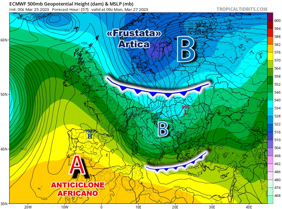
With the term “whipped” we really mean the impetuous and fast entry of the cold. The map below, of Central Europe, shows precisely the air currents of Arctic origin (blue color) descending from Scandinavia, driven by a vast depression centered on Eastern Europe (indicated with the letter “B”).
This is effectively a more than configuration winter mold than spring, with the coldest and most unstable air masses that will conclude their run in the Mediterranean basin, diving directly from the Porta della Bora. It is reasonable to expect a decidedly eventful phase, with a high probability of precipitation and a general drop in temperatures.
During the day of Monday 27 March, the Adriatic sectors and the South will be at risk of bad weather above all: given the season and the strong temperature contrasts, thunderstorms are expected (even of short duration alternating with sunny spaces) on lower Veneto, Romagna, Marche, Abruzzo, Molise, Puglia, Campania and Calabria. In addition to rainfall, we also expect stormy winds from the northern quadrants, with gusts up to almost 100 km/h and storm surges along the coasts most exposed to the fury of the currents. Considering the expected drop in temperature, snow will also return to the Apennines, with flakes by the evening starting from 8-900 meters of altitude. Precipitation will also extend throughout the day to the inland areas of Tuscany and Lazio.
Some rain will still be possible in the very first part of Tuesday 28, especially in the South and in Sicily: then there will be room for a rapid improvement on the front weather forecast, even if the temperatures will suffer a drastic drop also due to the intense winds from the northern quadrants. Especially on the plains of the North and in the internal areas of the Center in the early morning there will be teeth chattering with values close to 0°C. Subsequently, the anticyclone will return to reconquer the lost space, spreading over the Mediterranean basin: here it is legitimate expect greater atmospheric stability, with temperatures rising, especially in the maximum values, at least until Thursday 30.
For the end of the month the uncertainties increase: in fact, one cannot be excluded new cold perturbation with the risk of another bad weather phase from Friday 31st.
Subscribe to the newsletter
