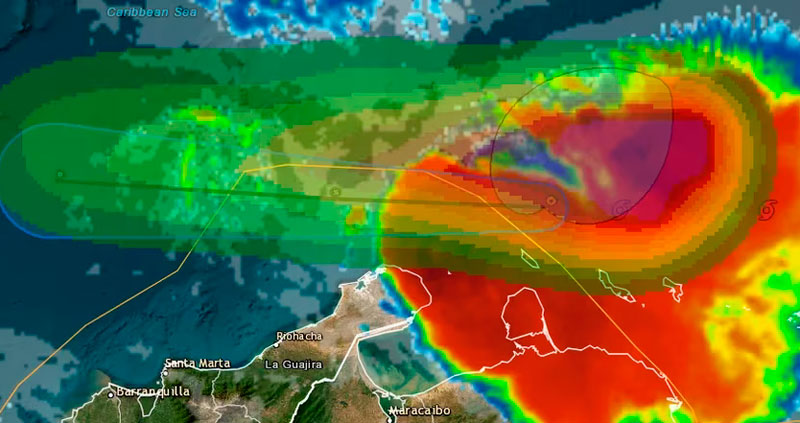
The department of La Guajira is under surveillance due to the imminent arrival of Bret, a tropical storm that has been crossing from the eastern Caribbean and is approaching the Colombian coast. The authorities have commissioned relief agencies and municipalities to remain alert to any type of novelty; Although at the moment only heavy rains are expected, it is not known what the development of the natural phenomenon will be.
Regarding the case, in its most recent report, the National Unit for Risk and Disaster Management pointed out that, from the United States, the National Hurricane Center highlighted the warning status for the eastern Colombian Caribbean; highlighting La Guajira as one of the areas that may be most affected, clearly, without ruling out San Andrés, although there is no latent threat for this Saturday, June 24 in said region.
“According to the latest NHC report, tropical storm BRET continues in the eastern Caribbean Sea. According to its alert cone, for the moment, the state of warning is maintained for the eastern Caribbean, specifically for the peninsula of La Guajira due to the rains that may occur, and a state of surveillance for the center of the national Caribbean Sea. No impact is expected in the area of the San Andrés and Providencia archipelago in the next 72 hours.
Waves of up to four meters in the Caribbean
The risk of flooding in some areas has to do with the high level of rainfall that could trigger climate depression, since the increase in rainfall will materialize after 8 am, the time when Bret’s tail will hit the national coasts. According to the Ungrd, the waves on the Colombian beaches in this area of the Caribbean could reach up to four meters high.
“For the Colombian Caribbean, a significant wave height is observed that oscillates between 2.5 and 3.5 meters, which mainly affects coastal and maritime areas of Puerto Bolivar, Barranquilla, Cartagena and the Archipelago of San Andres, Providencia and Santa Catalina. At the moment, these conditions are not directly related to the transit of tropical storm Bret, where a significant wave height of up to 4.0 meters is evident to the east of the Caribbean basin.
Meanwhile, in the north of the coast, it is estimated that the waves exceed three meters, but that they remain at a moderate frequency, although the risk is latent due to the effects that the tropical storm may unleash in Colombia.
“It is expected that in the next 24 hours the transit of this cyclonic system will affect the wind and wave conditions, mainly in maritime areas of the north of the Colombian Caribbean coast, with waves that will oscillate between 3.0 and 3.5 meters, or even higher. It is recommended to maximize security measures in the development of maritime activities.
Specific recommendations of the Ungrd for the arrival of Bret in Colombia
It is suggested to the Cdgrd and operational entities of the Sngrd to activate the protocols, contingency plans and all the follow-up and surveillance actions based on the prevention for the enlistment in the event of a possible increase in rainfall and increase in the height of the waves for the next few hours. in the Department of La Guajira.
For the next few days, maintain surveillance actions for the coastal areas of the departments of Atlántico, Magdalena, Bolívar, Córdoba, Sucre and Antioquia.
No impact is expected in the area of the Archipelago of San Andrés and Providencia in the next 72 hours.
Continue attentive to the official announcements of the Sngrd. with Infobae
