
The National Meteorological Service (SMN) issued a orange and yellow alert, for wind and rains, for the entire territory of Neuquén and Río Negro. Heavy rainfall is expected in the Andean area. The warning is for this Thursday, June 8.

The SMN detailed the places and times that will be affected by the alert:
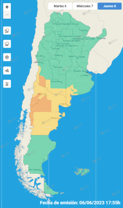
Alert for wind and rain in Neuquén, by area
East of Loncopué – East of Picunches – East of Ñorquín – West of Añelo – West of Pehuenches – South of Chos Malal – South of Minas: There is an alert for Thursday morning and afternoon. The area will be affected by winds from the west sector, with speeds between 55 and 70 km/h and gusts that can reach 100 km/h.
Confluence – East of Añelo – East of Pehuenches – Picún Leufú: The area will be affected by winds from the west sector, with speeds between 55 and 70 km/h and gusts that can reach 100 km/h. The warning is for Thursday morning and afternoon.
Catán Lil – Collón Curá – Zapala – Lower area of Aluminé – Lower area of Huiliches – Lower area of Lácar.: The area will be affected by winds from the west sector, with speeds between 70 and 90 km/h and gusts that can reach 120 km/h. There is a yellow alert for early morning and afternoon, and orange for Thursday afternoon.
The lakes: The area will be affected by heavy and persistent rains. Accumulated precipitation values between 30 and 60 mm are expected, and may be exceeded occasionally. Snowfall is not ruled out in the highest areas of the mountain range. In addition, the area will be affected by winds from the west sector, with speeds between 70 and 90 km/h and gusts that can reach 120 km/h. there is an orange alert (for wind and rain) for Thursday morning, and yellow for early morning and afternoon.
Cordillera de Huiliches – Cordillera de Lácar – South of Aluminé: The area will be affected by heavy rains. Accumulated precipitation values between 15 and 30 mm are expected, and may be exceeded occasionally. Snowfall is not ruled out in the highest areas of the mountain range. The rain warning is for the morning, afternoon and night of Thursday. In addition, there is a wind alert with speeds between 55 and 70 km/h and gusts that can reach 100 km/h, for the early morning, morning and afternoon of Thursday.
Alert for wind and rain in Río Negro, by area
East of El Cuy – General Roca: The area will be affected by winds from the west sector, with speeds between 55 and 70 km/h and gusts that can reach 100 km/h. There is an alert for Thursday morning and afternoon.
Pilcaniyeu Plateau – Ñorquinco Plateau – July 9 – West of El Cuy – May 25: lThe advisory is for Thursday morning and afternoon (yellow) and morning (orange). The area will be affected by winds from the west sector, with speeds between 70 and 90 km/h and gusts that can reach 120 km/h.
Bariloche – Pilcaniyeu Mountain Range – Ñorquinco Mountain Range: The area will be affected by heavy and persistent rains. Accumulated precipitation values between 30 and 60 mm are expected, and may be exceeded occasionally. Snowfall is not ruled out in the highest areas of the mountain range. Also, the area will be affected by winds from the west sector, with speeds between 70 and 90 km/h and gusts that can reach 120 km/h. There is an orange alert for wind and rain for Thursday morning, and yellow for early morning and afternoon.
Avellaneda – Pichi Mahuida: In the morning and afternoon. The area will be affected by winds from the west sector, with speeds between 55 and 70 km/h and gusts that can reach 100 km/h.
Conesa – Meseta de Adolfo Alsina – Meseta de San Antonio – Valcheta: yellow alert in the morning and afternoon of Thursday. The area will be affected by winds from the west sector, with speeds between 55 and 70 km/h and gusts that can reach 100 km/h.
What does orange and yellow alert mean
From the SMN they explained the different alert levels. Yellow indicates “possible weather phenomena with damage capacity and risk of momentary interruption of daily activities”. While orange, marks that “weather phenomena are expected dangerous for society, life, property and the environment”.