
one, live weather
1. Domestic situation
Typhoon “Plum” affects East China:From 08:00 yesterday to 06:00 today, there were heavy to heavy rains in parts of northern Zhejiang, southeastern Jiangsu and other places, and local heavy rains or extremely heavy rains (250-283 mm) in Shaoxing and Ningbo in Zhejiang.
Significant rainfall occurred in the Sichuan Basin:From 08:00 yesterday to 06:00 today, there were heavy rains or heavy rains in parts of the western Sichuan Basin, southern Guizhou, southern Yunnan, and western Guangxi, and local heavy rains (100-176 mm) in Mianyang and Leshan, Sichuan, and the maximum hourly rainfall in the above-mentioned areas. 30 to 70 mm.
2. Live abroad
Strong precipitation occurs in places such as the Indian peninsula and Southeast Asia:There are moderate to heavy rains, local heavy rains or heavy rains, and strong convective weather such as thunderstorms and strong winds in parts of the Indian Peninsula, Indo-China Peninsula, the Japanese Islands, the Greater Sunda Islands, the Great Lakes of the United States, the Labrador Peninsula, and West Africa.
High temperatures in West Asia and North Africa:The highest temperature in the Arabian Peninsula, Iranian Plateau, Indus Plain, Mesopotamian Plain, Algeria, Morocco, Egypt, Sudan, Niger, Libya, western France, southern United States, western Mexico, central Brazil, and northern Australia exceeded 35 ℃, among which, it reaches 38-40℃ in some areas, and exceeds 42℃ locally.
Second, the key weather forecast
1. Domestic key weather
(1) Typhoon“Plum Blossom” will land in the coastal areas of northern Zhejiang
The center of this year’s No. 12 typhoon “Meihua” (strong typhoon level) is located on the sea about 275 kilometers southeast of Xiangshan County, Zhejiang Province at 05:00 on the 14th. Pa, the radius of the seventh-level wind circle is 240-300 kilometers, the tenth-level wind circle radius is 80-100 kilometers, and the twelve-level wind circle radius is 50 kilometers.The Central Meteorological Observatory continued to issue an orange typhoon warning at 06:00 on September 14。
It is expected that “Plum Blossom” will move to the northwest at a speed of 20-25 kilometers per hour, and the intensity will be strengthened, gradually approaching the coast of northeastern Zhejiang, and will be in the area from Wenling to Zhoushan in Zhejiang from the afternoon to the night of the 14th. Landfall in coastal areas (typhoon level or strong typhoon level, 38-45 m/s, level 13-14); after landfall, “Plum Blossom” will continue to move to the northwest, and its intensity will gradually weaken (see Figure 1).
Affected by it, from 08:00 on September 14 to 08:00 on September 15, most of the East China Sea and the waters near the Diaoyu Islands, the central and southern waters of the Yellow Sea, the Yangtze River Estuary, Hangzhou Bay and the northern coast of Taiwan Island, the northern coast of Fujian, the southern coast of Shandong, Zhejiang There will be strong winds of magnitude 6-8 and gusts of magnitude 9-11 in the east, Shanghai, and eastern coastal areas of Jiangsu. Among them, there will be strong winds in the central and western seas of the East China Sea, the central and northern coasts of Zhejiang, the coasts of Shanghai, the southeastern coasts of Jiangsu, Hangzhou Bay, and the Yangtze River Estuary. Strong winds of magnitude 9-11, gusts of magnitude 12-14, and winds of magnitude 12-14 on the nearby sea or area where the “Plum Blossom” center passes, with gusts of magnitude 15-16.
Figure 1 Probability forecast map of typhoon “Meihua” in the next 60 hours
In addition, this year’s No. 14 typhoon “Nanmadol” (tropical storm level) (English name: Nanmadol; name origin: Micronesia; name meaning: the famous Pohnpei ruins) hit Kyushu Island, Japan at 02:00 on the 14th It is about 1480 kilometers southeast to the northwest Pacific Ocean, and it is expected to move to the northwest at a speed of 5-10 kilometers per hour, and its intensity will gradually increase. It will have no impact on my country’s waters in the next three days.
(2)There will be heavy rainfall in eastern China
Affected by typhoon “Meihua” and its trough, from September 14th to 16th, there will be heavy to heavy rains in eastern China, central and eastern Liaoning, among them, northern Zhejiang, Shanghai, eastern Jiangsu, Shandong Peninsula, and central and eastern Liaoning, etc. There are heavy rainstorms in some areas of the region. Locally heavy rainstorms in northeastern Zhejiang and other places, the cumulative rainfall can reach 50-150 mm, and the local area can reach more than 350 mm.
It is expected that from 08:00 on September 14 to 08:00 on September 15, there will be heavy to heavy rain in parts of Liaodong Peninsula, central and eastern Shandong, Shanghai, Jiangsu, eastern Anhui, central and northern Zhejiang, and central and western Sichuan Basin. Among them, eastern Jiangsu, There were heavy rainstorms in parts of Shanghai, northeastern Zhejiang and other places, and local heavy rains (250-280 mm) in northeastern Zhejiang. Some of the above-mentioned areas are accompanied by short-term heavy rainfall (the maximum hourly rainfall is 30-60 mm, and the local area can exceed 70 mm), and there are local strong convective weather such as thunderstorms and strong winds.The Central Meteorological Observatory continued to issue a yellow rainstorm warning at 06:00 on September 14(See Figure 2).
In addition, affected by the shear line, from the 14th to the 16th, there were moderate to heavy rains and local heavy rains in the western Sichuan Basin, western Guizhou, Yunnan and other places.
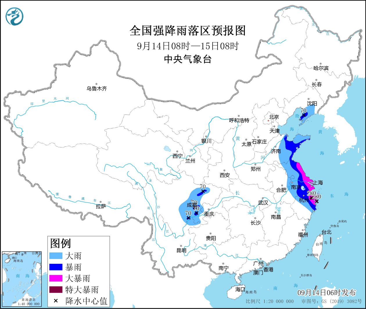
Figure 2 Forecast map of heavy rainfall areas across the country (08:00 on September 14th – 08:00 on September 15th)
2. Foreign key weather
(1) Strong precipitation in places such as the Great Lakes of the United States and Alaska in the Indo-China Peninsula of India
In the next three days, there will be moderate to heavy rains and local heavy rains in the Indian Peninsula, Indochina Peninsula, Indonesia, central Russia and the Far East, southern northern Europe, the Great Lakes and Alaska, eastern Canada, and southern Mexico. Thunderstorms will occur in some of the above areas. Strong convective weather such as strong winds.
(2) Continued high temperature in West Asia and North Africa
In the next three days, the Arabian Peninsula, the Mesopotamian Plain, the Indus Plain, North Africa, the United States and parts of western Mexico, northern Australia, the Brazilian Plateau and other places will have high temperature weather above 35°C, and parts of West Asia, North Africa and other places will have high temperatures above 35°C. The daily maximum temperature in the region exceeds 40°C.
3. Specific forecast for the next three days
From 08:00 on September 14th to 08:00 on the 15th,There were heavy to heavy rains in parts of Liaodong Peninsula, central and eastern Shandong, Shanghai, Jiangsu, eastern Anhui, central and northern Zhejiang, and central and western Sichuan Basin. Among them, there were heavy rains in parts of eastern Jiangsu, Shanghai, and northeastern Zhejiang. Some local heavy rains (250-280 mm). There will be winds of magnitude 4 to 6 in parts of Hexi in Gansu, northern Jiangsu, central Zhejiang and other places. There will be rotating winds of magnitude 10 to 11 in the southern part of the East China Sea, gusts of magnitude 12 reduced to magnitude 8 to 9, and gusts of magnitude 10. There will be rotating winds of magnitude 9-10 and gusts of magnitude 11 (see Figure 3).
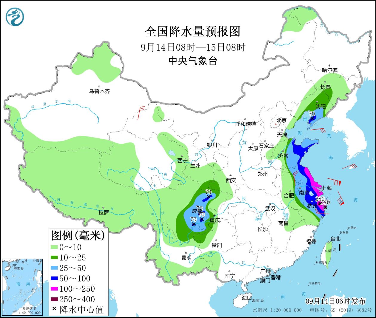
Figure 3 National precipitation forecast map (08:00 on September 14th – 08:00 on September 15th)
From 08:00 on September 15th to 08:00 on the 16th,There were moderate to heavy rains in parts of eastern Jilin, Liaoning, Shandong, central and northern Jiangsu, eastern Anhui, southeastern Sichuan, western Guizhou, northeastern Yunnan, and northwestern Guangxi. Among them, central Liaoning, central Shandong, and western Guizhou There are heavy rains or heavy rains (100-150 mm) in the area. There will be winds of magnitude 4 to 6 and above in parts of northwestern Inner Mongolia, the southern Xinjiang Basin, and northern Jiangsu, and there will be winds of magnitude 7 to 8, gusts of magnitude 9, and gusts of magnitude 7 in the southern waters of the Yellow Sea. With a southerly wind, there will be northeasterly winds of magnitude 5 to 7 and gusts of magnitude 8 in the Bohai Sea (see Figure 4).
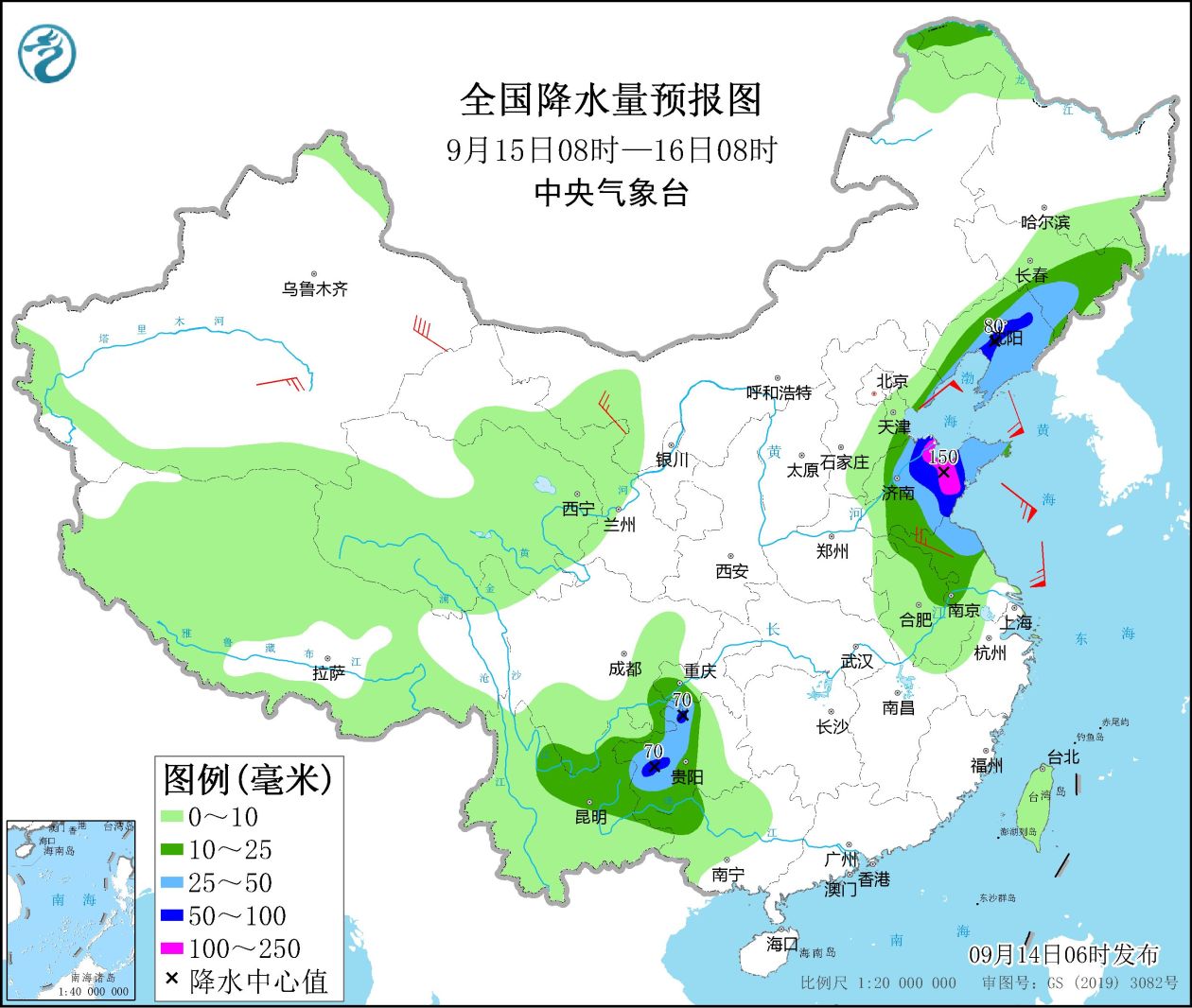
Figure 4 National precipitation forecast map (08:00 on September 15th – 08:00 on September 16th)
From 08:00 on September 16th to 08:00 on the 17th,There are moderate to heavy rains in parts of northeastern Inner Mongolia, Jilin and eastern Liaoning, eastern Yunnan, southern Guizhou, and western Guangxi. Among them, there are heavy rains or heavy rains (100-130 mm) in parts of central Liaoning and other places. There will be winds of magnitude 4 to 6 and above in parts of Liaoning and other places, the Bohai Sea will have winds of magnitude 7 to 8, the gust of magnitude 9 will be reduced to magnitude 6 to 7, and the gust of magnitude 8 will be northerly winds, and the Bohai Strait will have magnitudes of 6 to 7, The southeasterly to the southwesterly wind with a gust of magnitude 8 (see Figure 5).
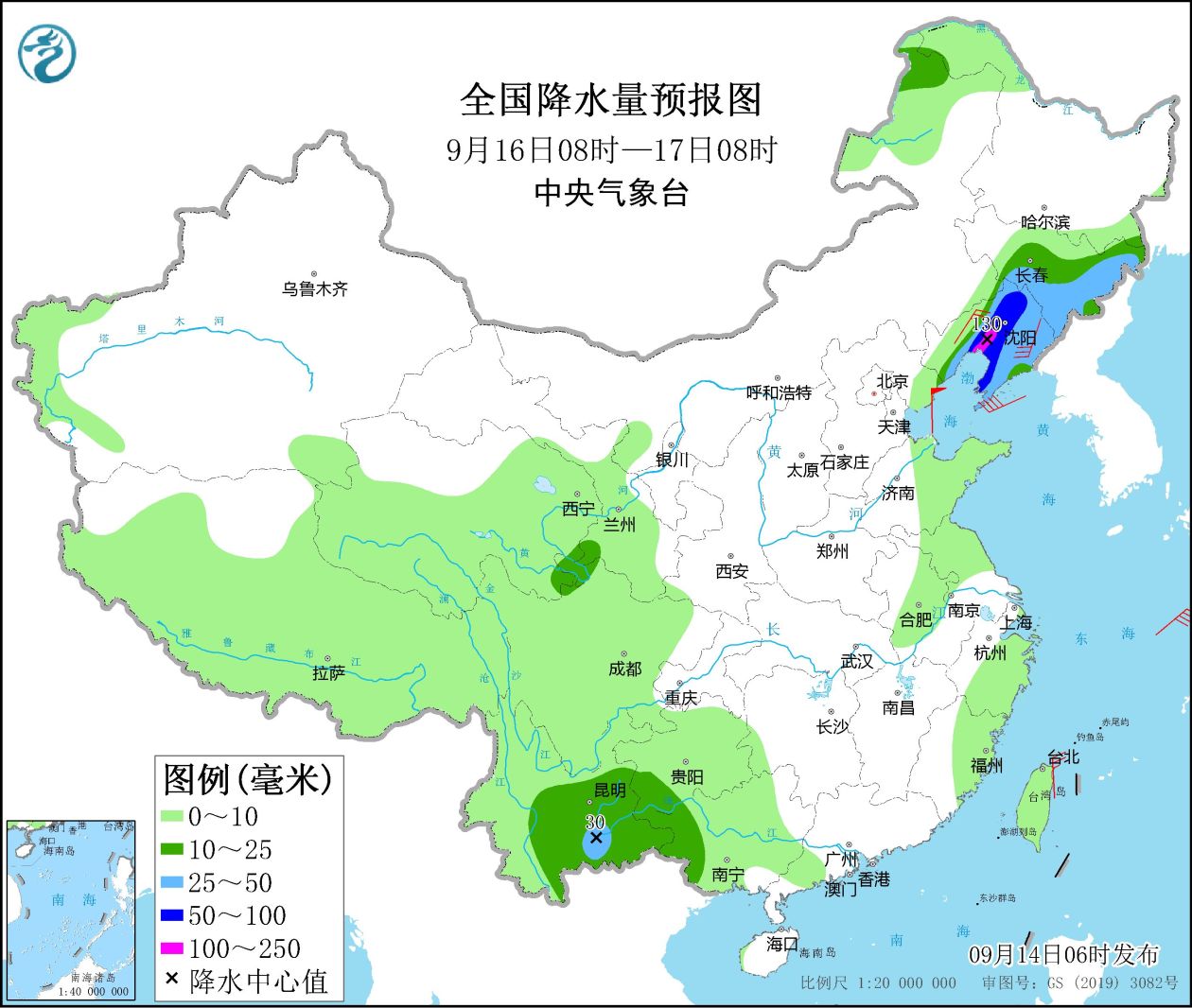
Figure 5 National precipitation forecast map (08:00 on September 16 – 08:00 on 17th)
4. Influence and Concern
1. Zhejiang, Shanghai, Jiangsu, Anhui, Shandong, Liaoning and other places and the eastern sea area of my country need to pay attention to the strong wind and rain and adverse effects caused by the typhoon “Plum Blossom”;
2. In Sichuan, Chongqing, Yunnan, Guizhou and other places with heavy rainfall, pay attention to possible flash floods and geological disasters;
3. Pay attention to the changing trends and impacts of meteorological droughts in the Yangtze River Basin.