
Within the framework of the study called ‘Neotectonics and paleoseismology of the Algeciras Fault, Huila, Colombia’, carried out by the Colombian Geological Service, he also referred to the San Agustín-El Agrado-Hobo Fault and the Suaza-Acevedo Fault. Second delivery.
Newspaper of Huila, Huila
By: Gloria Camargo
With the objective of “understanding one of the most dangerous geological structures in the country”, and under agreement 022 of 2019, the Colombian Geological Service (SGC) and the Pedagogical and Technological University of Colombia (UPTC) carried out the relevant studies in large part. del Huila to conclude with the publication called “Neotectonics and paleoseismology of the Algeciras Fault, Huila, Colombia”.
This was revealed by the Diario del Huila, in its first installment, called Algeciras Fault, would determine a seismic threat in the country, on April 18, where this means of communication managed to establish that the Algeciras Fault is one of the most geological structures. important and dangerous areas of Colombia, due to its history of producing large earthquakes in the recent geological past.
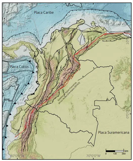
Which, according to the Universidad del Norte, which collaborated with the research, is vital because “the Border Fault System of the Eastern Andes, which extends from the Gulf of Guayaquil in Ecuador to the Caribbean coast of Venezuela, is known such as the Algeciras Fault System in Colombia and crosses several departments, including Nariño, Putumayo, Cauca, Huila, Caquetá and Meta”.
In addition, it is argued that “it has compelling evidence of being an active geological fault, capable of generating earthquakes of significant magnitudes.”
It should be remembered that the study delivered by the Colombian Geological Service, with the support of the Pedagogical and Technological University of Colombia, was carried out with resources from the General Royalty System, assigned to the Tectonic Model project of the SGC Geosciences Department. Researchers from the Geodynamics (formerly Tectonics) research groups of the Directorate of Basic Geosciences and Geodetic Research
Also highlighted that the “results allow progress in the knowledge of the Algeciras Fault System, probably the most representative fault system of continental Colombia in terms of its seismogenic potential, and provide valuable information for the advancement of knowledge of the country’s seismic threat ”.
Conclusions Algeciras Fault
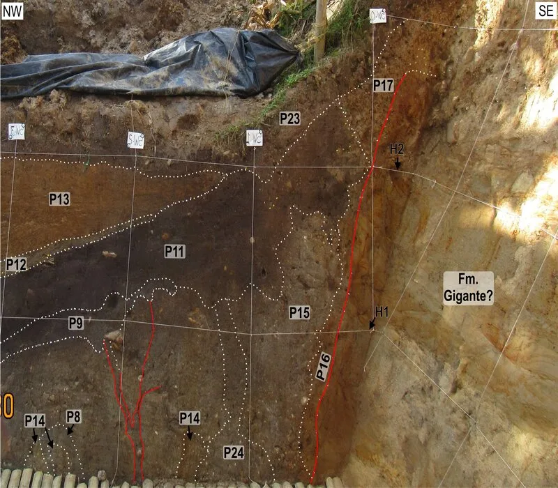
According to the report of the national entity, in the first place it was possible to identify fault traces previously unknown in the Algeciras Fault in Colombia, and its geometry and kinematics were fully described.
In addition, the paleoseismological analysis allowed to identify several historical earthquakes, including three in the Potrerillos trench, with dates of occurrence around AD 700, AD 1300 and AD 1815; and three in the Miraflores trench, with dates of occurrence in 1000 BC, a penultimate event with an uncertain date, and one in the 20th century.
It was discovered that both branches of the fault have behaved independently from the seismogenic point of view. The Garzón branch seems responsible for the earthquake of November 16, 1827, while the Tres Esquinas-Algeciras branch originated the one of February 6, 1967.
The geological data obtained are essential for the development of fault segmentation and seismic recurrence models, fundamental for the probabilistic analysis of the seismic hazard, for which it was established that the communities that live near the fault must take into account several actions. to prevent or mitigate the impact of an eventual earthquake, education being key.
Morphostructural analysis
In the section of the study carried out in the department of Huila, the SGC reiterated that the Algeciras Fault System (SFA) is an important part of the Eastern Andes Border Fault System (SFFAO) that obliquely crosses the entire width of the Cordillera Oriental and covers an extensive area of the Upper Magdalena Valley.
“This system consists of several interconnected and interlocking major faults, spanning a wide swath that varies between 20 and 40 km. The Algeciras Fault (FA) is the main fault of the system and is located in the southern part of the department of Huila, south of its capital Neiva, covering a distance of 126 km.
Therefore, it must be made clear that the SFA covers the part that extends from the village of El Paraíso, about 8 kilometers northeast of Algeciras, to San Agustín in the southwest.
The system covers the Upper Magdalena Valley, between the western external fault, the San Agustín-El Agrado-Hobo Fault (it is suggested to use the name El Agrado Fault) and the main fault of the system: the Algeciras Fault (FA). . Further south of Garzón, the system’s eastern outer fault is the Suaza-Acevedo Fault.
San Agustín-El Agrado-Hobo Fault
This fault originates 23 km west of Pitalito and near San Agustín, where, according to researchers, it is disconnected from the main branch of the system, the FA, and begins to head northeast. The fault follows the course of the Magdalena River downstream, where it exerts strong control over several straight sections of the river.
In addition, between the municipalities of Oporapa and Elías, the fault makes an abrupt turn to the east, while it continues in a straight line in a northeasterly direction, marking the edge of the Serranía de las Minas, eastern flank of the Central mountain range.
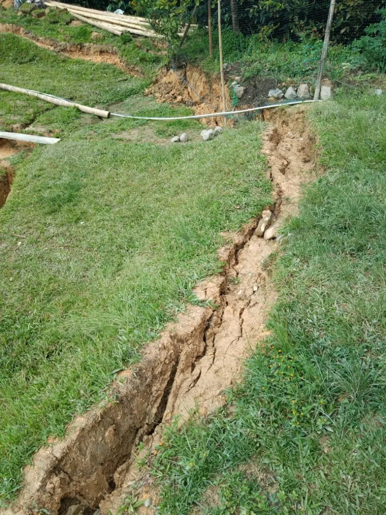
“In this sector, the fault shows a wide variety of morphotectonic features that indicate a notable degree of activity, such as displaced and deviated drainages, rake drainages, Quaternary terraced counterscarps, and triangular facets.”
In addition, the SGC establishes that “the trace of the fault is identified very close to El Agrado where due to its activity a small fault lagoon (sag pond) was formed, and at the confluence of the Páez river with the Magdalena river where it currently crosses. there is the dam of the El Quimbo dam”.
In addition to the fact that it crosses the alluvial fan of Hobo and its trace can be continued to the northeast, where it cuts crystalline rocks of Jurassic age on the western edge of the Eastern Cordillera. There, very deep longitudinal valleys associated with it are evident. Finally, near the village of El Paraíso, the FA converges with the main branch.
The part of the fault that marks the edge of the Serranía de las Minas, directly opposite that of Tarqui in the syncline, with the same name as the municipality and in the center of the Magdalena valley, seems to have displaced a very prominent ridge laterally to the north. of conglomerates and sandstones of the Gualanday Formation (Bache Formation), for a distance of approximately 10 km.
“Probably much of this horizontal displacement is apparent, since some of it may be reverse movement due to the vertical component of transcurrent fault. Speculatively, the 10 km distance of horizontal displacement might imply a fault displacement rate of 4 mm/a which appears to be a high value. Unfortunately, until now, no specific paleoseismological studies have been carried out to establish its displacement rate, nor its seismogenic potential”, the study states.
Falla de Suaza-Acevedo
It is considered one of the important geological structures in the country, which controls the Suaza river valley and constitutes the eastern limit of the Eastern Cordillera Fault System (SFA). However, this fault is part of a larger fault zone, which consists of two large parallel faults: the Palestine Fault and the Suaza-Acevedo Fault. Both are the result of a divergence of a fault that passes through the southern margin of the Sibundoy basin, in the Putumayo.
The Suaza-Acevedo Fault follows the valley of the Suaza River and marks the western limit of the Garzón Massif. And according to the study, “evidence of its activity has been observed in the form of morphotectonic indices, mainly due to an alignment of fault saddles, control over certain sections of the Suaza River and the presence of some traction basins. Kinematic indications have been found in several outcrops as fault striations, which show horizontal or slightly oblique right lateral displacement”.
Finally, it is established that “in the study area, the SFA covers the entire Magdalena river valley, but it is notable that the valley is confined only between the El Agrado Fault in the west and the main branch of the system, the FA in the east. The Suaza-Acevedo Fault does not interact until the point where the main fault, the FA, is located south of Garzón, from there to the southwest, the Suaza-Acevedo Fault does constitute the eastern limit of the SFA”.
Therefore, it was possible to specify that “the sedimentary fill of the southern Magdalena valley is mostly composed of deposits of Cenozoic age that rest on deposits of Cretaceous age and have been deformed by folding during phases of strong shortening, related to the subduction of the Nazca Plate, under the South American continent, in two phases during the Middle Miocene, from 12.5 Ma to 9 Ma, and the Mio-Pliocene, from 6 Ma to 3 Ma, which was the paroxysmal phase of the second part of the Andean orogeny during which the Eastern Cordillera rose.